
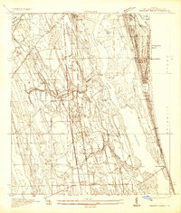
1943 Map of Matanzas
USGS Topo · Published 1957About this map
Ft Matanzas stands at the northern edge of this coastal survey, guarding the passage where the Matanzas Inlet meets the sea. This wartime-era mapping projects a landscape of barrier islands and tidal marshes, as seen just before the post-war development boom. The barrier strip is home to the scientific and tourist outpost of Marineland and the small coastal settlement of Summer Haven. Inland, the historical corridor of the Old Kings Road runs parallel to the coastline, tracing a path through the low-lying terrain near Pellicer Cr and the boundary between St Johns and Flagler counties. The hydrological network is dominated by the Intracoastal Waterway and the meandering Matanzas River, which together carve a distinct path through the wetlands and hammocks toward Dead Lake. Several survey benchmarks, including Scott and Rock BM 13, provide precise points of reference along the dunes and shoreline.
Find a feature on this map
18 named features on this map. Tap any name to fly to it.
Don’t see what you’re looking for? This feature index may not catch every label — zoom into the map to look around manually.
Map Details
Editions of this 1943 Matanzas Map
This is the sole edition of this map. No revisions or reprints were ever made.
Other maps of this area

1927 · Matanzas
USGS Topo · 1:48,000
1937 · Crescent Beach
USGS Topo · 1:24,000

1937 · Dinner Island
USGS Topo · 1:48,000

1937 · Ormond
USGS Topo · 1:48,000
1943 · St. Augustine
USGS Topo · 1:62,500

1943 · Dinner Island
USGS Topo · 1:62,500

1944 · Ormond
USGS Topo · 1:62,500

1944 · Dinner Island
USGS Topo · 1:62,500

1944 · Matanzas
USGS Topo · 1:62,500

1954 · Daytona Beach
USGS Topo · 1:250,000