
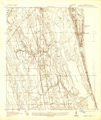
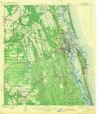
1944 Map of Matanzas
USGS Topo · Published 1944About this map
Ft Matanzas stands at the northern edge of this coastal survey, guarding the entrance to the Matanzas Inlet where the Matanzas River meets the Atlantic Ocean. During this mid-1940s period, the Florida coastline here shows a transition from historical defensive sites to burgeoning tourist and marine research destinations like Marineland and Summer Haven. The landscape is defined by the narrow strip of barrier island and the parallel course of the Intracoastal Waterway, which carves through the marshlands and lagoons inland from the coast.
Find a feature on this map
19 named features on this map. Tap any name to fly to it.
Don’t see what you’re looking for? This feature index may not catch every label — zoom into the map to look around manually.
Map Details
Editions of this 1944 Matanzas Map
This is the sole edition of this map. No revisions or reprints were ever made.
Other maps of this area

1927 · Matanzas
USGS Topo · 1:48,000
1937 · Crescent Beach
USGS Topo · 1:24,000

1937 · Dinner Island
USGS Topo · 1:48,000

1937 · Ormond
USGS Topo · 1:48,000
1943 · St. Augustine
USGS Topo · 1:62,500

1943 · Dinner Island
USGS Topo · 1:62,500

1943 · Matanzas
USGS Topo · 1:62,500

1944 · Ormond
USGS Topo · 1:62,500

1944 · Dinner Island
USGS Topo · 1:62,500

1954 · Daytona Beach
USGS Topo · 1:250,000