1940s Maps of Penney Farms, Florida
Explore 3 historic maps of Penney Farms from the 1940s. These maps offer a rare glimpse into what life looked like during the 1940s — showing old roads, neighborhoods, homes, and landmarks that have changed or disappeared over time.
Whether you're researching your family's past, planning a metal detecting trip, or studying how Penney Farms's landscape evolved across the 1940s, these high-resolution maps are a powerful tool for exploring the history of this region.
- Focus on a specific era: All maps on this page are from the 1940s, giving you a focused view of this time period.
- See what’s changed: Compare century-old streets, trails, and buildings to today's modern landscape using overlays and satellite layers.
- Research with precision: Use these maps for genealogy, historical research, land use analysis, or educational projects.
- View, download, or print: Maps are fully viewable online in high resolution, and can be downloaded or printed for your own records.
Start exploring Penney Farms's history through authentic maps from the 1940s. This is your window into the past.
Penney Farms, FL maps
(3)- 1942 Map of Ates Creek
 1942 Ates Creek1942 Print · USGSNorthern Florida's training grounds and rural settlements come into focus during the early mobilization of the Second World War. Researchers can trace the military layout of Camp Blanding alongside the agricultural colony at Penney Farms and the springs of Gold Head Branch.
 - 1949 Map of Penney Farms, 1953 Print
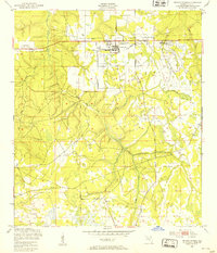 1949 Penney Farms1953 Print · USGSClay County at the end of the 1940s reveals a unique community structure centered on the retirement colony at Penney Farms. Researchers can locate specific sites like the Memorial Homes, the Penney Farms Sch, and the local Pass Station along the rail line.4 unique versions available
 - 1949 Map of Ates Creek, 1955 Print
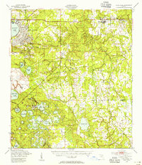 1949 Ates Creek1955 Print · USGSClay County during the post-war era shows a landscape transitioning between military readiness and civilian growth. Researchers can locate the sprawling Camp Blanding facilities, the planned community of Penney Farms, and historic sites like Beulah Cem.2 unique versions available
End of results
Showing maps 1-3 of 3
Top cities near Penney Farms
- Jacksonville historical maps
- Fruit Cove historical maps
- Middleburg historical maps
- Orange Park historical maps
- Green Cove Springs historical maps
- Keystone Heights historical maps
Frequently asked questions
- What are the different types of historical maps available for Penney Farms?
- What is the oldest map of Penney Farms?
- Where can I purchase historical maps of Penney Farms for my home or office?
- Where can I download high-res historical maps of Penney Farms?
- Are there historical topographic maps available for Penney Farms?
- Is there historical aerial imagery available for Penney Farms?
- Where are historical maps of Penney Farms sourced from?