Old Maps of Weavers Station, Florida for Hiking & Exploration
Hike through history with 10 historic maps of Weavers Station. Explore old trails, ghost towns, and forgotten backroads — perfect for outdoor adventurers and local explorers.
- Rediscover forgotten places: Map out old mining camps, roads, and footpaths that no longer exist on modern maps.
- Layer with modern tools: Combine with LiDAR or satellite views to plan hikes through historical terrain.
- Made for exploration: Popular among hikers, overlanders, and local history lovers.
Use these maps to find adventure and explore the hidden past of Weavers Station.
Weavers Station, FL maps
(10)- 1956 Map of Miami, 1963 Print
 1956 Miami1963 Print · USGSSouthern Florida experiences post-war expansion in the 1950s, even as the wilderness remains dominant across the southern peninsula. Genealogists and historians can trace suburban growth in Opa-locka and Perrine or locate remote sites like the Tamiami Ranger Station.5 unique versions available
 - 1958 Map of Miami
 1958 Miami1958 Print · USGSSoutheast Florida in the late fifties reveals a coastal boom held in balance with the wild sawgrass and mangroves of Everglades National Park. Trace the paths of the Florida East Coast RR through Homestead or locate the U S Marine Corps Air Station during the height of the Cold War.
 - 1972 Map of Weavers Station, 1976 Print
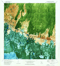 1972 Weavers Station1976 Print · USGSThe Florida Everglades meet the Gulf coast in the early 1970s, showcasing the intricate balance of cypress strands and coastal prairies. Researchers can trace the path of the Tamiami Trail as it passes Roadside Park and the headwaters of the Fakahatchee River.3 unique versions available
 - 1982 Map of Everglades City
 1982 Everglades City1982 Print · USGSSouthwest Florida's mangrove coasts and cypress strands appear in detailed transition during the early eighties as conservation boundaries expanded. Researchers can trace remote settlements like Lee Cypress and Copeland or explore the labyrinth of Thousand Islands.
 - 1988 Map of Miami
 1988 Miami1988 Print · USGSSouth Florida in the late eighties shows the sharp edge between the growing urban Atlantic coast and the vast wetlands of Everglades National Park. Researchers can trace the path of the Tamiami Trail and locate coastal settlements like Ochopee or Chokoloskee.
 - 2012 Map of Weavers Station, 2012 Print
 2012 Weavers Station2012 Print · USGSCovers Weavers Station, including Collier County, United States, and other nearby areas
 - 2015 Map of Weavers Station, 2015 Print
 2015 Weavers Station2015 Print · USGSCovers Weavers Station, including Collier County, United States, and other nearby areas
 - 2018 Map of Weavers Station, 2018 Print
 2018 Weavers Station2018 Print · USGSCovers Weavers Station, including Collier County, United States, and other nearby areas
 - 2021 Map of Weavers Station, 2021 Print
 2021 Weavers Station2021 Print · USGSCovers Weavers Station, including Collier County, United States, and other nearby areas
 - 2024 Map of Weavers Station, 2024 Print
 2024 Weavers Station2024 Print · USGSCoastal Collier County is shown here in the 2020s, dominated by the transition from cypress strand to tidal estuary. Researchers can trace the water flow through the Fakahatchee Strand and locate landmarks like Dan House Prairie or the protected Marjory Stoneman Douglas Wilderness.
End of results
Showing maps 1-10 of 10
Top cities near Weavers Station
- Marco Island historical maps
- Verona Walk historical maps
- Winding Cypress historical maps
- Everglades City historical maps
- Chokoloskee historical maps
- Goodland historical maps
See more
Frequently asked questions
- What are the different types of historical maps available for Weavers Station?
- What is the oldest map of Weavers Station?
- Where can I purchase historical maps of Weavers Station for my home or office?
- Where can I download high-res historical maps of Weavers Station?
- Are there historical topographic maps available for Weavers Station?
- Is there historical aerial imagery available for Weavers Station?
- Where are historical maps of Weavers Station sourced from?