1970s Maps of Duval County, Florida
Explore 4 historic maps of Duval County from the 1970s. These maps offer a rare glimpse into what life looked like during the 1970s — showing old roads, neighborhoods, homes, and landmarks that have changed or disappeared over time.
Whether you're researching your family's past, planning a metal detecting trip, or studying how Duval County's landscape evolved across the 1970s, these high-resolution maps are a powerful tool for exploring the history of this region.
- Focus on a specific era: All maps on this page are from the 1970s, giving you a focused view of this time period.
- See what’s changed: Compare century-old streets, trails, and buildings to today's modern landscape using overlays and satellite layers.
- Research with precision: Use these maps for genealogy, historical research, land use analysis, or educational projects.
- View, download, or print: Maps are fully viewable online in high resolution, and can be downloaded or printed for your own records.
Start exploring Duval County's history through authentic maps from the 1970s. This is your window into the past.
Duval County, FL maps
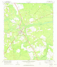
(4)- 1970 Map of Maxville, 1973 Print
 1970 Maxville1973 Print · USGSNorth Florida's timberlands and rail corridors are captured here in the early 1970s at the meeting of four counties. Genealogists and historians can trace the rural communities of Maxville and Hugh or locate old crossings at Turkey Creek and Bessent.2 unique versions available
 - 1970 Map of Callahan, 1973 Print
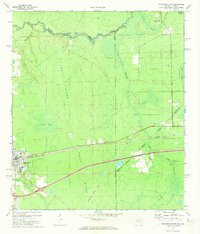
 1970 Callahan1973 Print · USGSNassau County's rural rail hubs and creek lands are captured here in the early 1970s. Trace local family history and transit lines near the Callahan junction, Mt Olive Ch, and the Jones Cem.4 unique versions available
 - 1972 Map of Macclenny East, 1973 Print
 1972 Macclenny East1973 Print · USGSThe Baker County seat and the Georgia state line meet in the early 1970s along the historic Trail Ridge. Trace the rail corridor of the Seaboard Coast Line through Macclenny and find local landmarks like Brandy Branch Ch and Mattox.
 - 1977 Map of Jacksonville, 1983 Print
 1977 Jacksonville1983 Print · USGSNortheast Florida during the late seventies shows a region defined by its deep-water naval bases and burgeoning riverfront suburbs. You can trace the rail networks of the Seaboard Coast Line, locate the Kingsley Plantation, and study the sprawling grounds of Cecil Field Naval Air Station.
End of results
Showing maps 1-4 of 4
Top cities of Duval County
- Jacksonville historical maps
- Jacksonville Beach historical maps
- Atlantic Beach historical maps
- Neptune Beach historical maps
- Baldwin historical maps
Frequently asked questions
- What are the different types of historical maps available for Duval County?
- What is the oldest map of Duval County?
- Where can I purchase historical maps of Duval County for my home or office?
- Where can I download high-res historical maps of Duval County?
- Are there historical topographic maps available for Duval County?
- Is there historical aerial imagery available for Duval County?
- Where are historical maps of Duval County sourced from?