1950s Maps of Duval County, Florida
Explore 19 historic maps of Duval County from the 1950s. These maps offer a rare glimpse into what life looked like during the 1950s — showing old roads, neighborhoods, homes, and landmarks that have changed or disappeared over time.
Whether you're researching your family's past, planning a metal detecting trip, or studying how Duval County's landscape evolved across the 1950s, these high-resolution maps are a powerful tool for exploring the history of this region.
- Focus on a specific era: All maps on this page are from the 1950s, giving you a focused view of this time period.
- See what’s changed: Compare century-old streets, trails, and buildings to today's modern landscape using overlays and satellite layers.
- Research with precision: Use these maps for genealogy, historical research, land use analysis, or educational projects.
- View, download, or print: Maps are fully viewable online in high resolution, and can be downloaded or printed for your own records.
Start exploring Duval County's history through authentic maps from the 1950s. This is your window into the past.
Duval County, FL maps
(19)- 1950 Map of Arlington
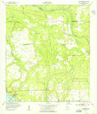
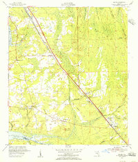
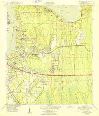 1950 Arlington1950 Print · USGSCoastal Duval County comes alive in the early fifties as the St. Johns River communities begin to expand eastward into the pine lands. Local researchers can trace family roots through several rural burial grounds like Gilmore Cem and Parsons Cem, or locate historic landmarks such as Craig Field and the ancient Indian Mound.2 unique versions available
 - 1950 Map of Mayport
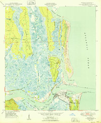 1950 Mayport1950 Print · USGSCoastal Duval County comes to life at the midpoint of the century, showing the intricate wetlands between the St. Johns River and Nassau Sound. Researchers can locate the Anderson Cem, the Ribault Monument, and the Abandoned Lighthouse near East Mayport.
 - 1950 Map of Trout River
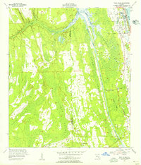
 1950 Trout River1950 Print · USGSNorth of Jacksonville in the early postwar era, the riverfront is a landscape of growing suburbs and civic institutions. Genealogists and local historians can locate family burial sites at Restlawn Memorial Park or trace the early days of the Jacksonville Municipal Airport.
 - 1950 Map of Eastport
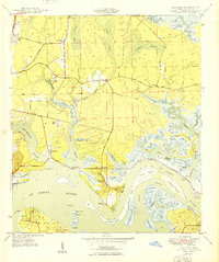 1950 Eastport1950 Print · USGSCoastal Duval County comes alive in this mid-century survey of the riverbanks and tidal marshes north of the city. Genealogists can trace family footprints through community anchors like New Berlin, the Dunn Creek Cem, and churches such as Oak Grove Ch.
 - 1950 Map of Jacksonville
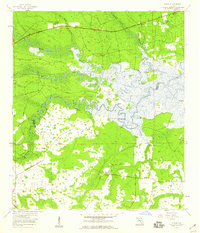
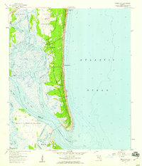
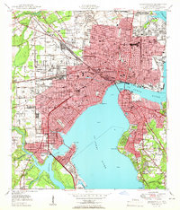 1950 Jacksonville1950 Print · USGSJacksonville at the dawn of the fifties was a thriving riverfront hub of industry and commerce. Genealogists and researchers can trace the city's layout through numerous local landmarks, from Union Station and Edward Waters College to neighborhoods like Ortega and St Nicholas.
 - 1952 Map of Orangedale, 1956 Print
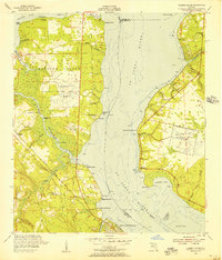
 1952 Orangedale1956 Print · USGSAlong the eastern bank of the St. Johns River in the early fifties, this area shows a landscape of riverfront crossings and deep hammock wetlands. Genealogists and local historians can trace the early footprints of Orangedale and Pine Bluff or locate historical sites like Blacks Ford and Ruins.2 unique versions available
 - 1952 Map of Orange Park, 1956 Print
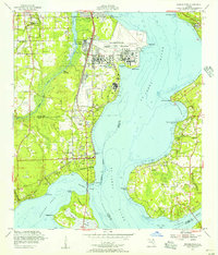 1952 Orange Park1956 Print · USGSOrange Park and Mandarin sit on opposite shores of the St. Johns River in the early fifties, caught between their agricultural roots and military growth. Genealogists and historians can trace family sites at Magnolia Cem, Bethel Ch, and the sprawling Jacksonville Naval Air Station.
 - 1952 Map of Durbin, 1956 Print
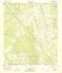 1952 Durbin1956 Print · USGSCoastal St. Johns County appears here in the early fifties, where the railroad and the Intracoastal Waterway dictate the local geography. Genealogists and historians can trace the small rail stops at Durbin and Hilden or locate the Lookout Tower and Ninemile Road.3 unique versions available
 - 1952 Map of Palm Valley, 1956 Print
 1952 Palm Valley1956 Print · USGSCoastal St. Johns County in the early fifties shows a landscape of developing beach communities and vast, untouched wetlands. Trace the early layout of Ponte Vedra Beach or explore the interior near Palm Valley Landing and the winding reaches of Durbin Swamp.2 unique versions available
 - 1952 Map of Bayard, 1956 Print
 1952 Bayard1956 Print · USGSCoastal Duval County in the early fifties shows a landscape of expansive swamps and emerging highway settlements. Researchers can trace the roots of local communities through landmarks like Julington Cem, Allen Chapel, and the Stockade near Pablo Creek.
 - 1952 Map of Fleming Island, 1956 Print
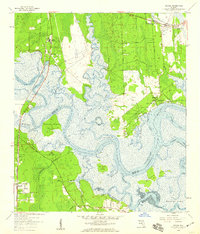
 1952 Fleming Island1956 Print · USGSThe St. Johns River corridor shows a transition toward modern aviation and infrastructure in the 1950s. Genealogists and local historians can trace family-named points and community hubs like St Margaret Ch, Hibernia, and the early Fleming Island Airfield.4 unique versions available
 - 1954 Map of Valdosta, 1967 Print
 1954 Valdosta1967 Print · USGSThe South Georgia and North Florida borderlands are captured here in the mid-fifties, showing the deep timber and wetland networks of the coastal plain. Researchers can trace the path of the Atlantic Coast Line through Valdosta or explore the interior of the Okefenokee Swamp.2 unique versions available
 - 1957 Map of Jacksonville, 1967 Print
 1957 Jacksonville1967 Print · USGSCoastal Florida and Georgia meet in the late fifties, showcasing a landscape of naval aviation, deep-water terminals, and barrier island communities. Researchers can trace the mid-century footprints of NAS Jacksonville, find small communities like Franklintown, and locate the historic Fort Clinch State Park.3 unique versions available
 - 1958 Map of Valdosta
 1958 Valdosta1958 Print · USGSSouth Georgia and North Florida are captured here in the mid-fifties, showing the vast Okefenokee Swamp and the vital timber and rail corridors connecting the two states. Researchers can locate the footprint of Moody Air Force Base, trace the Live Oak Perry and Gulf railroad, or find early community sites like Bakers Mill and Paradise Church.
 - 1958 Map of Italia, 1959 Print
 1958 Italia1959 Print · USGSThe Nassau and Duval county line in the late 1950s was a landscape of tide-influenced river bends and expansive wetlands. Researchers can trace historic river access at Joels Landing or locate local landmarks like Harpers Chapel and Ogilvie Cem.4 unique versions available
 - 1958 Map of Hedges, 1959 Print
 1958 Hedges1959 Print · USGSCoastal Nassau and Duval counties are captured in the late fifties as a landscape of tidal marshes and emerging railside settlements. Genealogists and researchers can trace local family landmarks like Bowles Cem and the landings at Jerry Landing and Henderson Landing.6 unique versions available
 - 1958 Map of Amelia City, 1959 Print
 1958 Amelia City1959 Print · USGSCoastal Amelia Island is captured here in the late fifties, showing the barrier island's early settlements and vast marsh systems. Researchers can locate the historic community of American Beach, the site of St Pauls Ch, and the winding Buccaneer Trail.6 unique versions available
 - 1959 Map of Valdosta
 1959 Valdosta1959 Print · USGSThe Georgia-Florida borderlands in the mid-fifties reveal a landscape of massive blackwater swamps and emerging military aviation hubs. Genealogists and historians can trace rail-stop towns like Fargo and Stockton or explore the interior reaches of the Okefenokee Swamp and Billys Island.
 - 1959 Map of Jacksonville
 1959 Jacksonville1959 Print · USGSNortheast Florida and Southeast Georgia are seen here in the late fifties, dominated by the maritime activity of the St Johns River and the Atlantic coast. Researchers can trace the mid-century layout of Jacksonville and identify sprawling military sites like Camp Blanding Military Reservation and Kings Bay Ammunition Terminal.
End of results
Showing maps 1-19 of 19
Top cities of Duval County
- Jacksonville historical maps
- Jacksonville Beach historical maps
- Atlantic Beach historical maps
- Neptune Beach historical maps
- Baldwin historical maps
Frequently asked questions
- What are the different types of historical maps available for Duval County?
- What is the oldest map of Duval County?
- Where can I purchase historical maps of Duval County for my home or office?
- Where can I download high-res historical maps of Duval County?
- Are there historical topographic maps available for Duval County?
- Is there historical aerial imagery available for Duval County?
- Where are historical maps of Duval County sourced from?