1990s Maps of Argyle Forest, Jacksonville
Explore 2 historic maps of Argyle Forest from the 1990s. These maps offer a rare glimpse into what life looked like during the 1990s — showing old roads, neighborhoods, homes, and landmarks that have changed or disappeared over time.
Whether you're researching your family's past, planning a metal detecting trip, or studying how Argyle Forest's landscape evolved across the 1990s, these high-resolution maps are a powerful tool for exploring the history of this region.
- Focus on a specific era: All maps on this page are from the 1990s, giving you a focused view of this time period.
- See what’s changed: Compare century-old streets, trails, and buildings to today's modern landscape using overlays and satellite layers.
- Research with precision: Use these maps for genealogy, historical research, land use analysis, or educational projects.
- View, download, or print: Maps are fully viewable online in high resolution, and can be downloaded or printed for your own records.
Start exploring Argyle Forest's history through authentic maps from the 1990s. This is your window into the past.
Argyle Forest, Jacksonville maps
(2)- 1993 Map of Jacksonville Heights
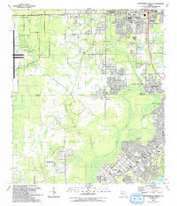 1993 Jacksonville Heights1993 Print · USGSGreater Jacksonville is captured in a moment of rapid suburban expansion in the early nineties, as military facilities met growing neighborhoods. Genealogists and historians can trace the foundations of Jacksonville Heights, locate the Federal Hill Cem, and see the extent of US Naval Air Station (Cecil Field).2 unique versions available
 - 1994 Map of Jacksonville Heights, 2002 Print
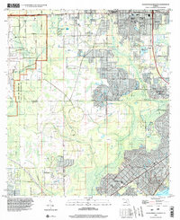 1994 Jacksonville Heights2002 Print · USGSWestern Jacksonville and northern Clay County appear in the mid-nineties during a phase of rapid suburban growth near military installations. Genealogists and local historians can trace family locations near Federal Hill Cem, Branan Field Ch, and the sprawling US Naval Air Station (Cecil Field).
End of results
Showing maps 1-2 of 2
Top cities near Argyle Forest
- Jacksonville historical maps
- Fruit Cove historical maps
- Middleburg historical maps
- Orange Park historical maps
- Green Cove Springs historical maps
- Baldwin historical maps
See more
Frequently asked questions
- What are the different types of historical maps available for Argyle Forest?
- What is the oldest map of Argyle Forest?
- Where can I purchase historical maps of Argyle Forest for my home or office?
- Where can I download high-res historical maps of Argyle Forest?
- Are there historical topographic maps available for Argyle Forest?
- Is there historical aerial imagery available for Argyle Forest?
- Where are historical maps of Argyle Forest sourced from?