1990s Maps of Dunn Creek, Jacksonville
Explore 1 historic maps of Dunn Creek from the 1990s. These maps offer a rare glimpse into what life looked like during the 1990s — showing old roads, neighborhoods, homes, and landmarks that have changed or disappeared over time.
Whether you're researching your family's past, planning a metal detecting trip, or studying how Dunn Creek's landscape evolved across the 1990s, these high-resolution maps are a powerful tool for exploring the history of this region.
- Focus on a specific era: All maps on this page are from the 1990s, giving you a focused view of this time period.
- See what’s changed: Compare century-old streets, trails, and buildings to today's modern landscape using overlays and satellite layers.
- Research with precision: Use these maps for genealogy, historical research, land use analysis, or educational projects.
- View, download, or print: Maps are fully viewable online in high resolution, and can be downloaded or printed for your own records.
Start exploring Dunn Creek's history through authentic maps from the 1990s. This is your window into the past.
Dunn Creek, Jacksonville maps
(1)- 1994 Map of Eastport, 2003 Print
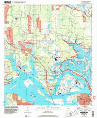 1994 Eastport2003 Print · USGSThe northern reaches of Jacksonville are shown in the 1990s as a hub of maritime industry and military presence along the St Johns River. Researchers can trace local heritage at Yellow Bluff Fort State Historical Site or locate family sites near Polly Town and Oak Grove Ch.
End of results
Showing maps 1-1 of 1
Top cities near Dunn Creek
- Jacksonville historical maps
- Jacksonville Beach historical maps
- St. Marys historical maps
- Atlantic Beach historical maps
- Fernandina Beach historical maps
- Neptune Beach historical maps
Frequently asked questions
- What are the different types of historical maps available for Dunn Creek?
- What is the oldest map of Dunn Creek?
- Where can I purchase historical maps of Dunn Creek for my home or office?
- Where can I download high-res historical maps of Dunn Creek?
- Are there historical topographic maps available for Dunn Creek?
- Is there historical aerial imagery available for Dunn Creek?
- Where are historical maps of Dunn Creek sourced from?