1960s Maps of Killarney Shores, Jacksonville
Explore 2 historic maps of Killarney Shores from the 1960s. These maps offer a rare glimpse into what life looked like during the 1960s — showing old roads, neighborhoods, homes, and landmarks that have changed or disappeared over time.
Whether you're researching your family's past, planning a metal detecting trip, or studying how Killarney Shores's landscape evolved across the 1960s, these high-resolution maps are a powerful tool for exploring the history of this region.
- Focus on a specific era: All maps on this page are from the 1960s, giving you a focused view of this time period.
- See what’s changed: Compare century-old streets, trails, and buildings to today's modern landscape using overlays and satellite layers.
- Research with precision: Use these maps for genealogy, historical research, land use analysis, or educational projects.
- View, download, or print: Maps are fully viewable online in high resolution, and can be downloaded or printed for your own records.
Start exploring Killarney Shores's history through authentic maps from the 1960s. This is your window into the past.
Killarney Shores, Jacksonville maps
(2)- 1960 Map of Jacksonville
 1960 Jacksonville1960 Print · USGSCoastal Florida and Georgia meet in this mid-century portrait of a region shaped by naval power and the winding St Johns River. Researchers can trace the development of military sites like Cecil Field or locate historic rural landmarks such as Jerusalem Ch and Kings Ferry.
 - 1963 Map of Arlington, 1965 Print
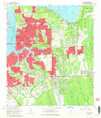 1963 Arlington1965 Print · USGSArlington and East Jacksonville are shown in a phase of significant suburban expansion just after the mid-century. Genealogists and researchers can trace the growth of Eggleston Heights and Southside Estates alongside landmarks like Parsons Cem and the Florida East Coast railway.6 unique versions available
End of results
Showing maps 1-2 of 2
Top cities near Killarney Shores
- Jacksonville historical maps
- Fruit Cove historical maps
- Ponte Vedra Beach historical maps
- Jacksonville Beach historical maps
- Atlantic Beach historical maps
- Orange Park historical maps
See more
Frequently asked questions
- What are the different types of historical maps available for Killarney Shores?
- What is the oldest map of Killarney Shores?
- Where can I purchase historical maps of Killarney Shores for my home or office?
- Where can I download high-res historical maps of Killarney Shores?
- Are there historical topographic maps available for Killarney Shores?
- Is there historical aerial imagery available for Killarney Shores?
- Where are historical maps of Killarney Shores sourced from?