1970s Maps of Chanticleer, Florida
Explore 2 historic maps of Chanticleer from the 1970s. These maps offer a rare glimpse into what life looked like during the 1970s — showing old roads, neighborhoods, homes, and landmarks that have changed or disappeared over time.
Whether you're researching your family's past, planning a metal detecting trip, or studying how Chanticleer's landscape evolved across the 1970s, these high-resolution maps are a powerful tool for exploring the history of this region.
- Focus on a specific era: All maps on this page are from the 1970s, giving you a focused view of this time period.
- See what’s changed: Compare century-old streets, trails, and buildings to today's modern landscape using overlays and satellite layers.
- Research with precision: Use these maps for genealogy, historical research, land use analysis, or educational projects.
- View, download, or print: Maps are fully viewable online in high resolution, and can be downloaded or printed for your own records.
Start exploring Chanticleer's history through authentic maps from the 1970s. This is your window into the past.
Chanticleer, FL maps
(2)- 1970 Map of Perdido Bay, 1971 Print
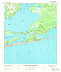 1970 Perdido Bay1971 Print · USGSPerdido Bay and the surrounding coastal reaches of Florida and Alabama are shown here during the early seventies. Researchers can trace the development of beachside communities like Seaglades and Gulf Beach or locate early marinas such as Holiday Harbor Marina.4 unique versions available
 - 1978 Map of Pensacola, 1980 Print
 1978 Pensacola1980 Print · USGSThe Gulf Coast at the end of the 1970s reveals a landscape shaped by maritime industry and a heavy naval presence. Researchers can trace the development of Pensacola alongside quiet coastal hamlets like Magnolia Springs and the historic Fort Pickens State Park.3 unique versions available
End of results
Showing maps 1-2 of 2
Top cities near Chanticleer
- Pensacola historical maps
- Ensley historical maps
- Foley historical maps
- Orange Beach historical maps
- Elberta historical maps
- Lillian historical maps
See more
Frequently asked questions
- What are the different types of historical maps available for Chanticleer?
- What is the oldest map of Chanticleer?
- Where can I purchase historical maps of Chanticleer for my home or office?
- Where can I download high-res historical maps of Chanticleer?
- Are there historical topographic maps available for Chanticleer?
- Is there historical aerial imagery available for Chanticleer?
- Where are historical maps of Chanticleer sourced from?