Old Maps of Escambia County, Florida
Explore 226 old maps of Escambia County, spanning from 1920 to today. These high-resolution historic maps reveal how streets, neighborhoods, landmarks, and natural features evolved over time — perfect for genealogy, metal detecting, research, and local history exploration.
What you can do with these maps:
- See how Escambia County changed over time: Compare historical maps to modern-day views to trace roads, homesites, rail lines & more.
- View detailed metadata: Each map includes creators, publishers, year, scale, and archive source.
- Overlay maps with satellite & LiDAR: Visualize the past alongside modern tools to explore terrain & human change.
- Trusted historical sources: Maps sourced from the USGS, Library of Congress, and other archives.
- Access maps your way: View online, download high-res files, or order prints for personal or research use.
Start exploring old maps of Escambia County to uncover forgotten places, hidden landmarks, and the deep history beneath your feet.
Escambia County, FL maps
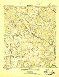
(226)- 1920 Map of Milton
 1920 Milton1920 Print · USGSSanta Rosa County's timber and rail economy is captured here just after the first World War. Genealogists and historians can trace the lumber industry through the Manu'g. and Land Co. R.R. and old coastal sites like Bagdad, Floridatown, and Roeville Sta.
 - 1920 Map of Robertsdale
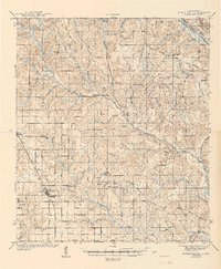
 1920 Robertsdale1920 Print · USGSBaldwin County at the end of the Great War reveals a landscape defined by the timber industry and early rail expansion. Genealogists can trace the rural footprints of Silverhill and Gateswood or follow the Logging Spur lines through the Burned Woods.
 - 1921 Map of Holley
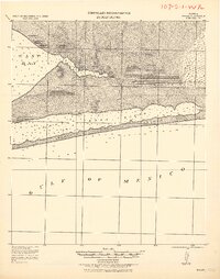 1921 Holley1921 Print · USGSThe Florida panhandle coastline near Holley appears here as it was in the early 1920s, a landscape of quiet sounds and barrier islands. Genealogists and researchers can trace old settlements and coastal landmarks like Harper, Hiawatha, and Manatee Pt.
 - 1921 Map of Bon Secour
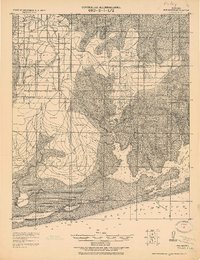 1921 Bon Secour1921 Print · USGSThe Alabama coast is captured here in the early twentieth century, showing a landscape of rail-connected towns and untouched shorelines. Researchers can trace early infrastructure like the Ft. Morgan and Summerdale RR and find quiet coastal outposts like Josephine P.O. and Bon Secour.2 unique versions available
 - 1921 Map of Pensacola
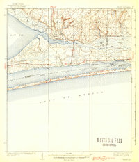
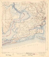
 1921 Pensacola1921 Print · USGSCoastal Florida in the early twentieth century reveals a landscape of maritime industry and military reserves. Map collectors and genealogists can trace the waterfront piers of Muscogee Wharf, the historic U. S. Live Oak Plantation, and early settlements like Bohemia.
 - 1921 Map of Fort Barrancas
 1921 Fort Barrancas1921 Print · USGSThe Florida-Alabama coast at the start of the 1920s reveals a landscape defined by naval history and maritime industry. Researchers can trace the military layout of Ft. Barrancas, locate Pensacola Light, and find vanished streets in Woolsey.
 - 1921 Map of Muscogee
 1921 Muscogee1921 Print · USGSThe Alabama-Florida borderlands come to life in the early 1920s, showing the river-and-rail network that sustained the region. Trace old ferry crossings like Billy Malone Ferry and landmarks such as Lathams Chapel and Seminola P.O.
 - 1936 Map of Holley
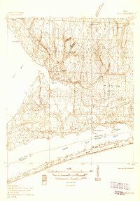 1936 Holley1936 Print · USGSThe Florida Panhandle coast near Santa Rosa County appears here during the mid-1930s, showing a quiet landscape of timber and wetlands. Genealogists and historians can trace early settlements at Holley and Navarre or locate landmarks like the Indian Head Fire Tower and Holley Ch.3 unique versions available
 - 1938 Map of Holley
 1938 Holley1938 Print · USGSThe Florida Panhandle's coastline and interior forests appear here in the mid-thirties, before modern development transformed the shore. Researchers can trace early settlements at Holley and Navarre or locate landmarks like the East Bay Ch and East Bay Ranger Station.3 unique versions available
 - 1941 Map of Fort Barrancas
 1941 Fort Barrancas1941 Print · USGSCoastal Florida and Alabama meet at the Perdido River during the early 1940s, showing a landscape of bayous, naval aviation, and growing bayside towns. Genealogists and historians can trace old homesteads near Millview, Fort Barrancas, and schools like Oakfield Sch.3 unique versions available
 - 1941 Map of Muscogee, 1956 Print
 1941 Muscogee1956 Print · USGSThe Florida-Alabama borderlands come alive in the early 1940s as the Perdido River and major rail lines dictate the rhythm of local commerce. Researchers can trace family roots through numerous rural landmarks like Barrineau Park, the Mission Cem, and Quintette Sch.2 unique versions available
 - 1941 Map of Robertsdale, 1956 Print
 1941 Robertsdale1956 Print · USGSCoastal Alabama's agricultural heartland is documented here just before mid-century, following the rail lines and river bends of the lower Perdido basin. Researchers can pinpoint early rural infrastructure from Old Mill Bridge to the Chandler Fire Tower and rural landmarks like Bethel Chapel or the CCC Camp.3 unique versions available
 - 1941 Map of Pensacola, 1956 Print
 1941 Pensacola1956 Print · USGSPensacola and its surrounding bays are seen here just before the mid-century boom, detailing a landscape defined by naval aviation and maritime rail. Trace the historic city grid, explore the U S Naval Reservation, or locate Oakland Ch and Black Hammock Cem.
 - 1941 Map of Milton, 1956 Print
 1941 Milton1956 Print · USGSSanta Rosa County at the start of the 1940s is shown here as a landscape of timber-towns and tidewater rail junctions. Genealogists can trace family names at Allen Cem, Robinson Sch, and the riverside settlements of Bagdad and Floridatown.2 unique versions available
 - 1941 Map of Century, 1962 Print
 1941 Century1962 Print · USGSThe Florida-Alabama borderlands come alive in the early 1940s as a landscape of river-bottom wetlands and upland rail towns. Genealogists can trace family roots at Coon Hill Cem, Kays Chapel, and long-standing schools like Pine Barren Sch.2 unique versions available
 - 1941 Map of Foley, 1964 Print
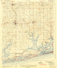
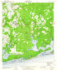 1941 Foley1964 Print · USGSCoastal Baldwin County in the early 1940s shows the working landscape of the Gulf before the era of major development. Researchers can trace the Louisville and Nashville Railroad line, find local landmarks like Stone Quarry Bayou, and locate early community sites such as Miflin Sch.3 unique versions available
 - 1942 Map of Pensacola
 1942 Pensacola1942 Print · USGSCoastal Florida is captured here in the early years of the war, showing the maritime and rail infrastructure that shaped the Panhandle. Genealogists and historians can trace family locations near Oakland Ch, the Black Hammock Cem, and the busy Muscogee Wharf.2 unique versions available
 - 1942 Map of Dyas, 1965 Print
 1942 Dyas1965 Print · USGSThe borderlands of Alabama and Florida are captured here during the early 1940s, highlighting a landscape shaped by timber and the Perdido River. Genealogists can locate family landmarks like Cain Cem, Nokomis Sch, and the St Stephens and St Louis RR.2 unique versions available
 - 1943 Map of Robertsdale
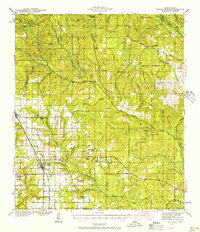
 1943 Robertsdale1943 Print · USGSCentral Baldwin County is shown here in the early 1940s, when timber work and rail lines defined the landscape. You can trace family roots at Rock Creek Cem, locate the Turpentine Camp, and find old schools like Blackwater Sch.3 unique versions available
 - 1943 Map of Muscogee
 1943 Muscogee1943 Print · USGSThe Florida-Alabama borderlands come alive in the early 1940s as the river-and-rail economy pulses through Muscogee and Cantonment. Genealogists can trace family footprints at Mission Cem, Sunnyhill Sch, and rural stops along the Louisville and Nashville RR.2 unique versions available
 - 1943 Map of Century
 1943 Century1943 Print · USGSThe Florida-Alabama borderlands in the 1940s are defined by the winding Escambia River and a thriving rail-and-timber network. Researchers can trace rural life through family-named landmarks like Coon Hill Cem, Ward Sch, and Chumuckla Springs.2 unique versions available
 - 1943 Map of Fort Barrancas
 1943 Fort Barrancas1943 Print · USGSThe Florida-Alabama borderlands at Perdido Bay come alive in the early 1940s, showing a landscape of coastal swamps and growing Pensacola suburbs. Researchers can trace the grounds of Fort Barrancas, locate Oakfield Sch, or find family roots near Millview and Seminole.2 unique versions available
 - 1943 Map of Milton
 1943 Milton1943 Print · USGSSanta Rosa and Escambia counties are captured here in the early 1940s at the confluence of the Blackwater and Escambia rivers. Researchers can trace the waterfront history of MILTON and Bagdad or locate rural landmarks like Union Valley Ch and Conners Still.2 unique versions available
 - 1943 Map of Foley
 1943 Foley1943 Print · USGSCoastal Baldwin County in the early 1940s shows a landscape of rail-end farming hubs and quiet bayou settlements before the rise of modern tourism. Genealogists and historians can trace local family roots through sites like Summerdale Cem, the Little Rock School, and the fishing village of Bon Secour.2 unique versions available
 - 1943 Map of Jay
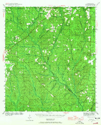
 1943 Jay1943 Print · USGSSanta Rosa County's agricultural and riverine heartland is captured here during the early years of the Second World War. Researchers can locate vanished landmarks like Catawba Fidelis Sch and Old Fidelis Cem or trace family roots in Jay and Chumuckla.4 unique versions available
Showing maps 1-25 of 226
Top cities of Escambia County
- Pensacola historical maps
- Ensley historical maps
- Century historical maps
- McDavid historical maps
- Molino historical maps
Frequently asked questions
- What are the different types of historical maps available for Escambia County?
- What is the oldest map of Escambia County?
- Where can I purchase historical maps of Escambia County for my home or office?
- Where can I download high-res historical maps of Escambia County?
- Are there historical topographic maps available for Escambia County?
- Is there historical aerial imagery available for Escambia County?
- Where are historical maps of Escambia County sourced from?