1960s Maps of Escambia County, Florida
Explore 3 historic maps of Escambia County from the 1960s. These maps offer a rare glimpse into what life looked like during the 1960s — showing old roads, neighborhoods, homes, and landmarks that have changed or disappeared over time.
Whether you're researching your family's past, planning a metal detecting trip, or studying how Escambia County's landscape evolved across the 1960s, these high-resolution maps are a powerful tool for exploring the history of this region.
- Focus on a specific era: All maps on this page are from the 1960s, giving you a focused view of this time period.
- See what’s changed: Compare century-old streets, trails, and buildings to today's modern landscape using overlays and satellite layers.
- Research with precision: Use these maps for genealogy, historical research, land use analysis, or educational projects.
- View, download, or print: Maps are fully viewable online in high resolution, and can be downloaded or printed for your own records.
Start exploring Escambia County's history through authentic maps from the 1960s. This is your window into the past.
Escambia County, FL maps
(3)- 1960 Map of Pensacola
 1960 Pensacola1960 Print · USGSThe Florida Panhandle and Alabama's eastern shore are shown during a period of rapid military and coastal growth. Genealogists and historians can trace the mid-century footprints of Warrington, the Pensacola NAS (Chevalier), and the Blackwater River timber lands.
 - 1969 Map of Gulf Breeze, 1971 Print
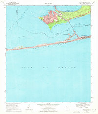 1969 Gulf Breeze1971 Print · USGSThe Florida Panhandle coast near Pensacola comes alive in this late-sixties study of a growing peninsula community. Researchers can trace the Andrew Jackson Trail, find the St Anna Ch, and explore the shoreline from Grassy Point to Fort Pickens State Park.3 unique versions available
 - 1969 Map of Oriole Beach, 1971 Print
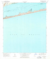 1969 Oriole Beach1971 Print · USGSThe Florida Panhandle coastline shows its mid-century character as the residential hubs of Gulf Breeze and Oriole Beach expand. Trace the early development of Santa Rosa Island along Via Deluna and the sand dunes of Big Sabine Point.4 unique versions available
End of results
Showing maps 1-3 of 3
Top cities of Escambia County
- Pensacola historical maps
- Ensley historical maps
- Century historical maps
- McDavid historical maps
- Molino historical maps
Frequently asked questions
- What are the different types of historical maps available for Escambia County?
- What is the oldest map of Escambia County?
- Where can I purchase historical maps of Escambia County for my home or office?
- Where can I download high-res historical maps of Escambia County?
- Are there historical topographic maps available for Escambia County?
- Is there historical aerial imagery available for Escambia County?
- Where are historical maps of Escambia County sourced from?