1990s Maps of Escambia County, Florida
Explore 18 historic maps of Escambia County from the 1990s. These maps offer a rare glimpse into what life looked like during the 1990s — showing old roads, neighborhoods, homes, and landmarks that have changed or disappeared over time.
Whether you're researching your family's past, planning a metal detecting trip, or studying how Escambia County's landscape evolved across the 1990s, these high-resolution maps are a powerful tool for exploring the history of this region.
- Focus on a specific era: All maps on this page are from the 1990s, giving you a focused view of this time period.
- See what’s changed: Compare century-old streets, trails, and buildings to today's modern landscape using overlays and satellite layers.
- Research with precision: Use these maps for genealogy, historical research, land use analysis, or educational projects.
- View, download, or print: Maps are fully viewable online in high resolution, and can be downloaded or printed for your own records.
Start exploring Escambia County's history through authentic maps from the 1990s. This is your window into the past.
Escambia County, FL maps
(18)- 1994 Map of Perdido Bay
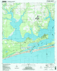
 1994 Perdido Bay1994 Print · USGSCoastal Florida and Alabama meet at Perdido Bay in the mid-nineties, showing a landscape of growing beach communities and protected seashores. Trace local landmarks like the Holiday Harbor Marina, the residential blocks of Gulf Beach, and the wild expanses of Rabbit Island.
 - 1994 Map of Dyas, 1998 Print
 1994 Dyas1998 Print · USGSBaldwin County at the Florida border in the mid-1990s shows a landscape of creek-side settlements and rural crossroads. Genealogists and local historians can trace the Old Pensacola Road or locate the Cain Cem and Horseneck Ch.
 - 1994 Map of Orange Beach, 1998 Print
 1994 Orange Beach1998 Print · USGSThe Alabama coast in the mid-nineties shows the intricate meeting of bayou and beach before modern development peaked. Researchers can trace the legacy of coastal settlements like Josephine, locate the Lay Cem, and explore the 1994 layout of Gulf State Park.
 - 1994 Map of Gateswood, 1998 Print
 1994 Gateswood1998 Print · USGSBaldwin County's river-cut timberlands are documented here in the mid-nineties, showing the rural communities near the Florida border. Trace local history at Gateswood or locate family sites like Hamilton Cem and the Bellefontaine Sch.
 - 1994 Map of Fort Barrancas, 1998 Print
 1994 Fort Barrancas1998 Print · USGSThe Florida coast near Pensacola was a critical hub of naval aviation and coastal defense during the mid-nineties. Trace the grounds of the Barrancas National Cemetery or the historic military remains at Fort Barrancas and Fort Pickens Ruins.
 - 1994 Map of Dogwood Creek, 1998 Print
 1994 Dogwood Creek1998 Print · USGSCoastal Alabama's timberlands and river bottoms are captured here in the mid-1990s just as the landscape remained deeply rural. Genealogists and historians can trace family locations near Pine Grove, High Pine Cem, and the historic Wiggins Still.2 unique versions available
 - 1994 Map of Bay Springs, 1998 Print
 1994 Bay Springs1998 Print · USGSThe Florida Panhandle north of Pensacola is captured here in the mid-1990s, centered on the rural settlements of Bay Springs and McKinnon. Researchers can trace the local landscape through features like the Cem, old industrial sites such as a Sandpit, and the sprawling Champion International State Wildlife Management Area.2 unique versions available
 - 1994 Map of Enon, 1998 Print
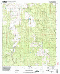
 1994 Enon1998 Print · USGSThe Florida-Alabama border along the Perdido River is captured here in the mid-1990s. Trace the rural landscape near Enon to find local landmarks like Holly Grove Cem and the La Floresta Perdida Airport.2 unique versions available
 - 1994 Map of Lillian, 1999 Print
 1994 Lillian1999 Print · USGSThe Alabama-Florida border comes alive in the mid-nineties as the Perdido River flows into the bay near Lillian. Researchers can trace local heritage at the Old Spanish Cem or explore the military footprint of Pensacola NAS OLF Bronson.
 - 1994 Map of Barrineau Park, 1999 Print
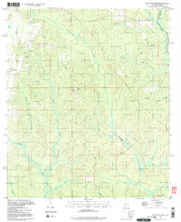
 1994 Barrineau Park1999 Print · USGSThe Florida-Alabama borderlands along the Perdido River remained a landscape of rural churches and creek-side settlements in the mid-nineties. Genealogists can trace family landmarks like St Elizabeth Ch, Tenile, and the Barrineau Park Sch.2 unique versions available
 - 1994 Map of McDavid, 1999 Print
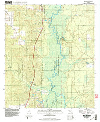 1994 McDavid1999 Print · USGSIn the mid-nineties, the Escambia River floodplain remained a wilderness of oxbows and timber tracts punctuated by quiet Florida panhandle settlements. Genealogists and local historians can trace family locations at Coon Hill Cem, Bays Chapel, and the communities of McDavid and Barth.2 unique versions available
 - 1994 Map of Pace, 1999 Print
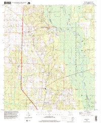
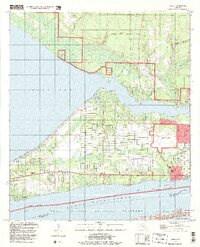
 1994 Pace1999 Print · USGSThe Escambia River delta and the growing suburbs of Pensacola are captured here in the mid-1990s as the region's industrial and academic footprints expanded. Researchers can trace the layout of the University of West Florida or locate historic sites like Whitmires Cem and Floridatown.
 - 1994 Map of Molino, 1999 Print
 1994 Molino1999 Print · USGSThe Escambia River bottomlands meet rural Florida panhandle settlements in the mid-1990s. Genealogists and local historians can trace legacy sites like Barrineau Cem, Molino Sch, and the community of Quintette along the western ridges.
 - 1994 Map of West Pensacola, 1999 Print
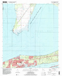
 1994 West Pensacola1999 Print · USGSWestern Escambia County comes into focus in the mid-1990s, showing the deep integration of military bases and suburban development. Genealogists and historians can trace the growth of Myrtle Grove and Warrington near Saufley Field and the shore of Perdido Bay.
 - 1994 Map of Pensacola, 1999 Print
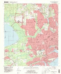
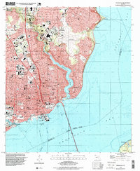 1994 Pensacola1999 Print · USGSPensacola and its waterfront neighborhoods are shown during the mid-nineties, capturing the city's development from the bay shore to the regional airport. Genealogists and historians can trace local landmarks like Holy Cross Cemetery, the historic Muscogee Wharf, and St Josephs Ch.
 - 1994 Map of Holley, 1999 Print
 1994 Holley1999 Print · USGSCoastal Santa Rosa County in the late nineties shows a landscape defined by military aviation and protected shorelines. Genealogists and local historians can trace family sites in Holley and Harper, find the local Cem, or locate landmarks like Tom King Bayou.
 - 1994 Map of Cantonment, 2000 Print
 1994 Cantonment2000 Print · USGSNorth of Pensacola in the 1990s, this area reflects a complex mix of heavy industry, military outposts, and riverfront wetlands. Researchers can locate community landmarks like Plainview Cem Ch, the Louisville and Nashville rail line, and the Escambia River islands.
 - 1994 Map of Garcon Point, 2000 Print
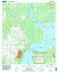
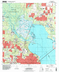
 1994 Garcon Point2000 Print · USGSSanta Rosa County's coastal reaches are documented here during a period of residential growth between the great bays in the mid-nineties. Local historians can trace established neighborhoods like Oriole Beach and Woodlawn Beach or locate sites like St Pauls Ch and Black Hammock Cem.
End of results
Showing maps 1-18 of 18
Top cities of Escambia County
- Pensacola historical maps
- Ensley historical maps
- Century historical maps
- McDavid historical maps
- Molino historical maps
Frequently asked questions
- What are the different types of historical maps available for Escambia County?
- What is the oldest map of Escambia County?
- Where can I purchase historical maps of Escambia County for my home or office?
- Where can I download high-res historical maps of Escambia County?
- Are there historical topographic maps available for Escambia County?
- Is there historical aerial imagery available for Escambia County?
- Where are historical maps of Escambia County sourced from?