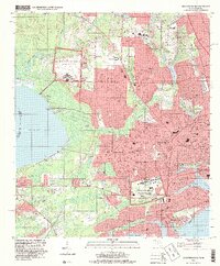
1994 Map of West Pensacola
USGS Topo · Published 1999About this map
The sprawling military presence at U S Navy Air Base Saufley Field and the U S Naval Technical Training Center anchors the mid-1990s landscape of western Escambia County. This map details the suburban expansion between Perdido Bay and Pensacola Bay, where established neighborhoods like Myrtle Grove and Bellview are woven through with mid-century landmarks like the Fairgrounds and Stone Technical Center.
Find a feature on this map
83 named features on this map. Tap any name to fly to it.
Don’t see what you’re looking for? This feature index may not catch every label — zoom into the map to look around manually.
Map Details
Editions of this 1994 West Pensacola Map
This is the sole edition of this map. No revisions or reprints were ever made.
Other maps of this area

1920 · Milton
USGS Topo · 1:62,500

1921 · Pensacola
USGS Topo · 1:62,500

1921 · Fort Barrancas
USGS Topo · 1:62,500

1921 · Muscogee
USGS Topo · 1:62,500

1941 · Fort Barrancas
USGS Topo · 1:62,500

1941 · Muscogee
USGS Topo · 1:62,500

1941 · Pensacola
USGS Topo · 1:62,500

1941 · Milton
USGS Topo · 1:62,500

1942 · Pensacola
USGS Topo · 1:62,500

1943 · Muscogee
USGS Topo · 1:62,500