
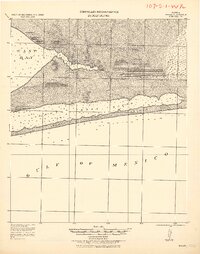
1920 Map of Milton
USGS Topo · Published 1920About this map
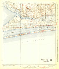
Milton and the surrounding timberlands of Santa Rosa County are depicted here in a Progressive Military Map produced shortly after the Great War. The landscape is defined by the heavy presence of the lumber industry, particularly evident through the Manu'g. and Land Co. R.R. and several narrow gauge lines threading through the pines to reach mill sites and shipping points. These rail networks connect the interior forests to coastal settlements like Bagdad and Floridatown, which served as critical hubs for processing and waterborne transport.
Find a feature on this map
33 named features on this map. Tap any name to fly to it.
Don’t see what you’re looking for? This feature index may not catch every label — zoom into the map to look around manually.
Map Details
Editions of this 1920 Milton Map
This is the sole edition of this map. No revisions or reprints were ever made.
Other maps of this area
1921 · Holley
USGS Topo · 1:62,500

1921 · Pensacola
USGS Topo · 1:62,500

1921 · Fort Barrancas
USGS Topo · 1:62,500

1921 · Muscogee
USGS Topo · 1:62,500
1934 · Harold
USGS Topo · 1:62,500
1936 · Holley
USGS Topo · 1:48,000
1937 · Harold
USGS Topo · 1:62,500
1938 · Holley
USGS Topo · 1:62,500
1938 · Harold
USGS Topo · 1:62,500

1941 · Fort Barrancas
USGS Topo · 1:62,500