
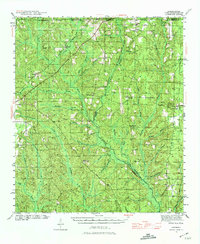
1942 Map of Dyas
USGS Topo · Published 1965About this map
The Perdido River carves a winding boundary between Alabama and Florida in this early 1940s survey, defining a landscape of dense pine forests and rural crossroads. The St Stephens and St Louis RR cuts diagonally across the northern terrain, serving timber and transit needs between small railside communities like Dyas and Carney. The presence of the High Pine Gem mine and multiple fire lookouts, including the Walnut Fire Tower and Bingham Fire Tower, points to an era when forestry and natural resource extraction were central to the local economy.
Find a feature on this map
59 named features on this map. Tap any name to fly to it.
Don’t see what you’re looking for? This feature index may not catch every label — zoom into the map to look around manually.
Map Details
Editions of this 1942 Dyas Map
2 editions found
Other maps of this area

1920 · Robertsdale
USGS Topo · 1:62,500

1921 · Fairhope
USGS Topo · 1:62,500

1921 · Muscogee
USGS Topo · 1:62,500

1941 · Bay Minette
USGS Topo · 1:62,500

1941 · Muscogee
USGS Topo · 1:62,500

1941 · Robertsdale
USGS Topo · 1:62,500

1941 · Century
USGS Topo · 1:62,500

1941 · Fairhope
USGS Topo · 1:62,500

1942 · Perdido
USGS Topo · 1:62,500

1943 · Robertsdale
USGS Topo · 1:62,500