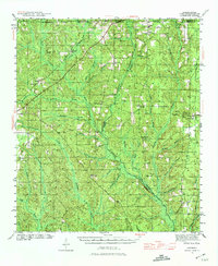
1942 Map of Dyas
USGS Topo · Published 1974About this map
The Perdido River meanders along the border of Baldwin and Escambia counties, defining a landscape of creek-fed timberlands and small rural communities during the early 1940s. The Louisville and Nashville railroad serves as a primary transit corridor, connecting the settlements of Dyas, Carney, and Pinchona. This survey, conducted just as the United States entered World War II, captures a network of country schools and churches that served as the social anchors for these remote townships, including Nokomis Sch and Antioch Ch.
Find a feature on this map
47 named features on this map. Tap any name to fly to it.
Don’t see what you’re looking for? This feature index may not catch every label — zoom into the map to look around manually.
Map Details
Editions of this 1942 Dyas Map
2 editions found
Other maps of this area

1920 · Robertsdale
USGS Topo · 1:62,500

1921 · Fairhope
USGS Topo · 1:62,500

1921 · Muscogee
USGS Topo · 1:62,500

1941 · Bay Minette
USGS Topo · 1:62,500

1941 · Muscogee
USGS Topo · 1:62,500

1941 · Robertsdale
USGS Topo · 1:62,500

1941 · Century
USGS Topo · 1:62,500

1941 · Fairhope
USGS Topo · 1:62,500

1942 · Perdido
USGS Topo · 1:62,500

1942 · Dyas
USGS Topo · 1:62,500