1950s Maps of Flagler County, Florida
Explore 9 historic maps of Flagler County from the 1950s. These maps offer a rare glimpse into what life looked like during the 1950s — showing old roads, neighborhoods, homes, and landmarks that have changed or disappeared over time.
Whether you're researching your family's past, planning a metal detecting trip, or studying how Flagler County's landscape evolved across the 1950s, these high-resolution maps are a powerful tool for exploring the history of this region.
- Focus on a specific era: All maps on this page are from the 1950s, giving you a focused view of this time period.
- See what’s changed: Compare century-old streets, trails, and buildings to today's modern landscape using overlays and satellite layers.
- Research with precision: Use these maps for genealogy, historical research, land use analysis, or educational projects.
- View, download, or print: Maps are fully viewable online in high resolution, and can be downloaded or printed for your own records.
Start exploring Flagler County's history through authentic maps from the 1950s. This is your window into the past.
Flagler County, FL maps
(9)- 1954 Map of Daytona Beach, 1974 Print
 1954 Daytona Beach1974 Print · USGSNortheast Florida is captured in the mid-1950s, showing the transition from river-based commerce to coastal tourism. Researchers can trace the Florida East Coast rail lines and find historic sites like Castillo de San Marcos Nat Mon and Palatka.
 - 1956 Map of Dinner Island NE, 1960 Print
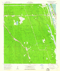
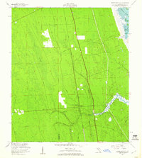 1956 Dinner Island NE1960 Print · USGSThe coastal wetlands of St. Johns and Flagler Counties are captured here in the mid-fifties, just as the modern era met the old Florida landscape. Genealogists and local historians can trace legacy routes like the Old Kings Road and locate rural landmarks such as Pellicer Creek Cem and Midway Ch.4 unique versions available
 - 1956 Map of Favoretta, 1960 Print
 1956 Favoretta1960 Print · USGSThe borderlands of Flagler and Volusia counties are captured here in the mid-1950s, defined by the expansive wetlands of the Florida lowlands. Researchers can trace the rail corridor at Favoretta or locate the site of the Tomoka Airport and National Gardens.5 unique versions available
 - 1956 Map of Matanzas Inlet, 1960 Print
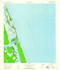 1956 Matanzas Inlet1960 Print · USGSAlong the Atlantic coast in the mid-1950s, this area preserves the strategic landscape surrounding the Matanzas Inlet. Researchers can trace the early layout of Summer Haven and Marineland, or explore the historical site of Ft Matanzas on the Matanzas River.4 unique versions available
 - 1956 Map of Flagler Beach East, 1960 Print
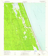
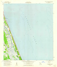 1956 Flagler Beach East1960 Print · USGSThe Florida coast at Flagler Beach is shown in the mid-fifties as the region's inland waterways and marshes remained largely undeveloped. Researchers can trace the Intracoastal Waterway past Mound Grove and locate the U S Coast Guard Reservation.3 unique versions available
 - 1956 Map of Flagler Beach West, 1960 Print
 1956 Flagler Beach West1960 Print · USGSCoastal Florida in the mid-fifties is captured here as the interior marshes met growing transit corridors. Researchers can trace the legacy of the Florida East Coast railway or find local landmarks like the Good Hope Cem and Bulow Ruins State Monument.5 unique versions available
 - 1956 Map of Beverly Beach, 1961 Print
 1956 Beverly Beach1961 Print · USGSThe Florida coast in the mid-fifties shows a delicate balance between new beachfront growth and the wild interior marshes. Genealogists and historians can trace the early layout of Beverly Beach or locate sites like Johnson Memorial Chapel and the historic Old Kings Road.5 unique versions available
 - 1957 Map of Espanola, 1960 Print
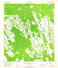
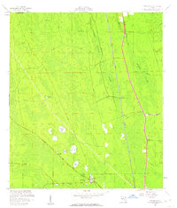 1957 Espanola1960 Print · USGSFlagler County's flatwoods and cypress strands are captured here in the late fifties, showing a landscape defined by rail and early roads. Genealogists and local historians can trace the community of Espanola, locating the St Pauls Ch, Espanola Cem, and the path of the Old Brick Road.5 unique versions available
 - 1958 Map of Daytona Beach
 1958 Daytona Beach1958 Print · USGSThe Florida coast and St. Johns River valley are captured in the late 1950s, showing a landscape defined by citrus-belt rail towns and Atlantic shorelines. Genealogists can trace family roots through riverside settlements like Palatka and Welaka or coastal hubs like Daytona Beach.2 unique versions available
End of results
Showing maps 1-9 of 9
Top cities of Flagler County
- Palm Coast historical maps
- Flagler Beach historical maps
- Bunnell historical maps
- Beverly Beach historical maps
Frequently asked questions
- What are the different types of historical maps available for Flagler County?
- What is the oldest map of Flagler County?
- Where can I purchase historical maps of Flagler County for my home or office?
- Where can I download high-res historical maps of Flagler County?
- Are there historical topographic maps available for Flagler County?
- Is there historical aerial imagery available for Flagler County?
- Where are historical maps of Flagler County sourced from?