Old Maps of Bunnell, Florida
Explore 20 old maps of Bunnell, spanning from 1912 to today. These high-resolution historic maps reveal how streets, neighborhoods, landmarks, and natural features evolved over time — perfect for genealogy, metal detecting, research, and local history exploration.
What you can do with these maps:
- See how Bunnell changed over time: Compare historical maps to modern-day views to trace roads, homesites, rail lines & more.
- View detailed metadata: Each map includes creators, publishers, year, scale, and archive source.
- Overlay maps with satellite & LiDAR: Visualize the past alongside modern tools to explore terrain & human change.
- Trusted historical sources: Maps sourced from the USGS, Library of Congress, and other archives.
- Access maps your way: View online, download high-res files, or order prints for personal or research use.
Start exploring old maps of Bunnell to uncover forgotten places, hidden landmarks, and the deep history beneath your feet.
Bunnell, FL maps
(20)- 1912 Map of Palatka
 1912 Palatka1912 Print · USGSCovers Bunnell, including Palatka, Pomona Park, and other nearby areas
 - 1915 Map of Palatka
 1915 Palatka1915 Print · USGSCovers Bunnell, including Palatka, Pomona Park, and other nearby areas7 unique versions available
 - 1937 Map of Dinner Island
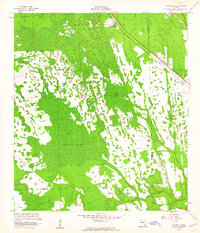
 1937 Dinner Island1937 Print · USGSCovers Bunnell, including Palm Coast, Espanola, and other nearby areas
 - 1937 Map of Ormond
 1937 Ormond1937 Print · USGSCovers Bunnell, including Palm Coast, Daytona Beach, and other nearby areas
 - 1943 Map of Dinner Island, 1957 Print
 1943 Dinner Island1957 Print · USGSCovers Bunnell, including Palm Coast, Espanola, and other nearby areas
 - 1944 Map of Ormond
 1944 Ormond1944 Print · USGSCovers Bunnell, including Palm Coast, Daytona Beach, and other nearby areas2 unique versions available
 - 1944 Map of Dinner Island
 1944 Dinner Island1944 Print · USGSCovers Bunnell, including Palm Coast, Espanola, and other nearby areas
 - 1954 Map of Daytona Beach, 1974 Print
 1954 Daytona Beach1974 Print · USGSCovers Bunnell, including Palm Coast, Daytona Beach, and other nearby areas
 - 1956 Map of Favoretta, 1960 Print
 1956 Favoretta1960 Print · USGSCovers Bunnell, including Daytona Beach, Ormond Beach, and other nearby areas5 unique versions available
 - 1956 Map of Flagler Beach West, 1960 Print
 1956 Flagler Beach West1960 Print · USGSCovers Bunnell, including Palm Coast, Flagler Beach, and other nearby areas5 unique versions available
 - 1957 Map of Espanola, 1960 Print
 1957 Espanola1960 Print · USGSCovers Bunnell, including Palm Coast, Espanola, and other nearby areas5 unique versions available
 - 1958 Map of Daytona Beach
 1958 Daytona Beach1958 Print · USGSCovers Bunnell, including Palm Coast, Daytona Beach, and other nearby areas2 unique versions available
 - 1964 Map of Daytona Beach
 1964 Daytona Beach1964 Print · USGSCovers Bunnell, including Palm Coast, Daytona Beach, and other nearby areas
 - 1968 Map of San Mateo, 1971 Print
 1968 San Mateo1971 Print · USGSCovers Bunnell, including Pomona Park, San Mateo, and other nearby areas3 unique versions available
 - 1970 Map of Bunnell, 1973 Print
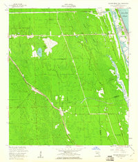
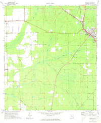 1970 Bunnell1973 Print · USGSCovers Bunnell, including Palm Coast, Black Point, and other nearby areas4 unique versions available
 - 1970 Map of Dinner Island, 1973 Print
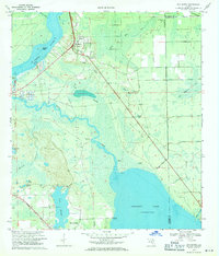
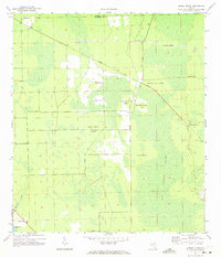 1970 Dinner Island1973 Print · USGSCovers Bunnell, including Roy, Shell Bluff, and other nearby areas3 unique versions available
 - 1972 Map of St. Johns Park, 1973 Print
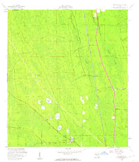
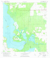 1972 St. Johns Park1973 Print · USGSCovers Bunnell, including Andalusia, New Run, and other nearby areas4 unique versions available
 - 1972 Map of Codys Corner, 1973 Print
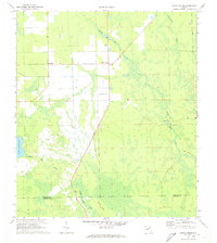 1972 Codys Corner1973 Print · USGSCovers Bunnell, including Deanville, Relay, and other nearby areas3 unique versions available
 - 1978 Map of Daytona Beach, 1980 Print
 1978 Daytona Beach1980 Print · USGSCovers Bunnell, including Palm Coast, Daytona Beach, and other nearby areas2 unique versions available
 - 1981 Map of Saint Augustine, 1982 Print
 1981 Saint Augustine1982 Print · USGSCovers Bunnell, including Palm Coast, Saint Augustine, and other nearby areas2 unique versions available
End of results
Showing maps 1-20 of 20
Top cities near Bunnell
- Palm Coast historical maps
- Daytona Beach historical maps
- Ormond Beach historical maps
- Flagler Beach historical maps
- Pierson historical maps
- Crescent City historical maps
See more
Top neighborhoods of Bunnell
- Andalusia historical maps
- Shell Bluff historical maps
- Bimini historical maps
- Black Point historical maps
- Relay historical maps
Frequently asked questions
- What are the different types of historical maps available for Bunnell?
- What is the oldest map of Bunnell?
- Where can I purchase historical maps of Bunnell for my home or office?
- Where can I download high-res historical maps of Bunnell?
- Are there historical topographic maps available for Bunnell?
- Is there historical aerial imagery available for Bunnell?
- Where are historical maps of Bunnell sourced from?