1980s Maps of Port Saint Joe, Florida
Explore 3 historic maps of Port Saint Joe from the 1980s. These maps offer a rare glimpse into what life looked like during the 1980s — showing old roads, neighborhoods, homes, and landmarks that have changed or disappeared over time.
Whether you're researching your family's past, planning a metal detecting trip, or studying how Port Saint Joe's landscape evolved across the 1980s, these high-resolution maps are a powerful tool for exploring the history of this region.
- Focus on a specific era: All maps on this page are from the 1980s, giving you a focused view of this time period.
- See what’s changed: Compare century-old streets, trails, and buildings to today's modern landscape using overlays and satellite layers.
- Research with precision: Use these maps for genealogy, historical research, land use analysis, or educational projects.
- View, download, or print: Maps are fully viewable online in high resolution, and can be downloaded or printed for your own records.
Start exploring Port Saint Joe's history through authentic maps from the 1980s. This is your window into the past.
Port Saint Joe, FL maps
(3)- 1982 Map of Overstreet, 1983 Print
 1982 Overstreet1983 Print · USGSCoastal Gulf County comes into focus in the early eighties as the shoreline meets the deep panhandle wetlands. Researchers can trace the path of the Intracoastal Waterway through Cypress Swamp and locate landmarks like the Lookout Tower near Overstreet.
 - 1982 Map of Port St. Joe, 1983 Print
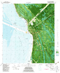 1982 Port St. Joe1983 Print · USGSPort St. Joe and the surrounding Gulf Coast lowlands are captured here in the early eighties as a mix of industrial activity and historical preservation. Trace local roots at Old St. Joseph Cem or explore the remnants of the Old Railroad Grade and Rifle Range.2 unique versions available
 - 1988 Map of Apalachicola
 1988 Apalachicola1988 Print · USGSThe Florida Panhandle's Forgotten Coast comes to life in the late eighties, showing the delicate balance between wild marshlands and historic waterfront towns. Researchers can trace the shoreline from Cape San Blas to Bald Point, locating family-named landings like Hays Place and the historic grounds of Fort Gadsden.
End of results
Showing maps 1-3 of 3
Top neighborhoods of Port Saint Joe
- Niles historical maps
- Ward Ridge historical maps
- Milltown historical maps
- North Port St. Joe historical maps
- WindMark Beach historical maps
Frequently asked questions
- What are the different types of historical maps available for Port Saint Joe?
- What is the oldest map of Port Saint Joe?
- Where can I purchase historical maps of Port Saint Joe for my home or office?
- Where can I download high-res historical maps of Port Saint Joe?
- Are there historical topographic maps available for Port Saint Joe?
- Is there historical aerial imagery available for Port Saint Joe?
- Where are historical maps of Port Saint Joe sourced from?