1900s (20th Century) Maps of Wewahitchka, Florida
Explore 9 historic maps of Wewahitchka from the 1900s (20th Century). These maps offer a rare glimpse into what life looked like during the 1900s — showing old roads, neighborhoods, homes, and landmarks that have changed or disappeared over time.
Whether you're researching your family's past, planning a metal detecting trip, or studying how Wewahitchka's landscape evolved across the 1900s, these high-resolution maps are a powerful tool for exploring the history of this region.
- Focus on a specific era: All maps on this page are from the 1900s, giving you a focused view of this time period.
- See what’s changed: Compare century-old streets, trails, and buildings to today's modern landscape using overlays and satellite layers.
- Research with precision: Use these maps for genealogy, historical research, land use analysis, or educational projects.
- View, download, or print: Maps are fully viewable online in high resolution, and can be downloaded or printed for your own records.
Start exploring Wewahitchka's history through authentic maps from the 1900s. This is your window into the past.
Wewahitchka, FL maps
(9)- 1945 Map of Dead Lake
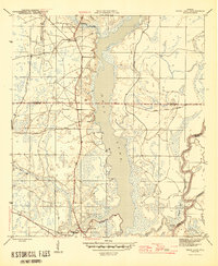 1945 Dead Lake1945 Print · USGSThe river and swamp country of the Florida Panhandle is captured here at the end of the war, revealing a landscape defined by its waterways. Researchers can trace historic river landings and family sites like Kentucky Ldg, Iola, and Jehu Cem.4 unique versions available
 - 1945 Map of Wewahitchka
 1945 Wewahitchka1945 Print · USGSGulf County river life in the mid-1940s centered on the confluence of the Chipola and Apalachicola. Researchers can trace historic river access at Cockran Landing or locate family roots in settlements like Wewahitchka, Honeyville, and Dalkeith.4 unique versions available
 - 1954 Map of Tallahassee, 1967 Print
 1954 Tallahassee1967 Print · USGSThe Florida Panhandle and South Georgia are captured here during a period of mid-century growth and military expansion. Researchers can trace the development of Panama City, the footprint of Tyndall Air Force Base, and the rail lines of the Atlantic Coast Line.4 unique versions available
 - 1959 Map of Tallahassee
 1959 Tallahassee1959 Print · USGSFlorida's Panhandle and the Big Bend region appear here in the mid-fifties, showing a landscape defined by its great river systems and developing coast. Trace the early layout of Panama City, the expansive Apalachicola National Forest, and the coastal St Marks Lighthouse.
 - 1960 Map of Tallahassee
 1960 Tallahassee1960 Print · USGSThe Florida Panhandle and southern Georgia are captured here in the mid-twentieth century, showing a region defined by its rivers and military installations. Genealogists and historians can trace the growth of Tallahassee or locate coastal landmarks like the St Marks Lighthouse and Tyndall Air Force Base.
 - 1981 Map of Panama City
 1981 Panama City1981 Print · USGSPanama City and the Florida Panhandle coast are captured here in the early eighties, showing the region's balance of military installations and maritime industry. Researchers can trace the Atlanta and St Andrews Bay RR or locate coastal sites like Tyndall Air Force Base and Dead Lake.2 unique versions available
 - 1988 Map of Tallahassee
 1988 Tallahassee1988 Print · USGSThe Florida Panhandle and South Georgia are captured here in the late eighties, showing the expansion of the regional highway network and coastal growth. Genealogists and historians can trace rail lines like the Seaboard System Railroad or locate family roots in Blountstown, Graceville, or Crawfordville.2 unique versions available
 - 1990 Map of Wewahitchka
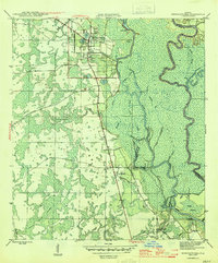
 1990 Wewahitchka1990 Print · USGSGulf County at the close of the twentieth century shows a landscape defined by the winding Apalachicola River and its many sloughs. Genealogists and local historians can locate Williamsburg Cem, trace the community at Dalkeith, and identify old river landings like Cochran Landing.
 - 1990 Map of Dead Lakes
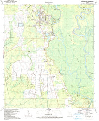
 1990 Dead Lakes1990 Print · USGSThe Florida Panhandle's riverine landscape comes to life in this map centered on Wewahitchka and the sprawling Dead Lakes system. Researchers can trace historical property lines at the Forbes Purchase Boundary or locate family sites near Jehu Cem and Chipola Park.
End of results
Showing maps 1-9 of 9
Top cities near Wewahitchka
Top neighborhoods of Wewahitchka
Frequently asked questions
- What are the different types of historical maps available for Wewahitchka?
- What is the oldest map of Wewahitchka?
- Where can I purchase historical maps of Wewahitchka for my home or office?
- Where can I download high-res historical maps of Wewahitchka?
- Are there historical topographic maps available for Wewahitchka?
- Is there historical aerial imagery available for Wewahitchka?
- Where are historical maps of Wewahitchka sourced from?