Old Maps of Stalvey Oaks, Florida for Genealogy
Trace your family roots with 13 historic maps of Stalvey Oaks. These high-res maps reveal old neighborhoods, homesites, landmarks, and streets — helping you uncover where your ancestors lived and how the area evolved over time.
- Explore historic neighborhoods: Identify where your relatives may have lived in the 1800s or 1900s.
- Compare maps over time: Trace the changes in streets, buildings, and landmarks for multi-generational research.
- Perfect for genealogy & ancestry research: Used by family historians and researchers to map out lineage and migration.
These maps are an incredible resource for exploring your personal connection to Stalvey Oaks's past.
Stalvey Oaks, FL maps
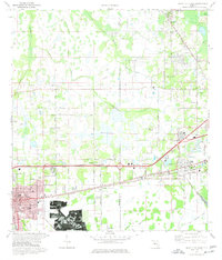
(13)- 1944 Map of Plant City
 1944 Plant City1944 Print · USGSMid-century Hillsborough and Polk counties are captured here during a time of significant military activity. Researchers can find old Florida landmarks like Enon Church, the Winston School, and the wartime footprints of Drane Field US Army.2 unique versions available
 - 1955 Map of Plant City, 1966 Print
 1955 Plant City1966 Print · USGSMid-century Central Florida comes to life in this survey of the Nature Coast and the inland citrus and rail belt. Genealogists and historians can trace the paths of the Atlantic Coast Line, locate the Anclote Keys Lighthouse, or find old communities like Masaryktown and Lacoochee.6 unique versions available
 - 1958 Map of Plant City
 1958 Plant City1958 Print · USGSFlorida's Gulf Coast and inland ridge country are captured here in the mid-fifties, showing the region before modern sprawl. Genealogists and historians can trace rail-era towns like Richland and Trilby or locate coastal landmarks such as the Anclote Keys Lighthouse.
 - 1959 Map of Plant City
 1959 Plant City1959 Print · USGSThe West Florida coast and inland timberlands are captured here in the late fifties, from the bend of the Gulf to the rail hubs of the interior. Trace the paths of the Atlantic Coast Line through Inverness and find landmarks like the Anclote Keys Lighthouse.
 - 1964 Map of Plant City
 1964 Plant City1964 Print · USGSThe West Florida coast and its interior rail corridors come alive in this mid-sixties survey, spanning from the gulf marshes to the agricultural heartland. Researchers can trace the routes of the Atlantic Coast Line through settlements like Bushnell, Inverness, and Plant City.
 - 1975 Map of Plant City East, 1977 Print
 1975 Plant City East1977 Print · USGSFlorida's phosphate country and the growth of Plant City are captured here in the mid-seventies, just as suburban expansion met industrial extraction. Trace family roots and local history at Oaklawn Cem, the strip mines near Youmans, or the Winston Sch.3 unique versions available
 - 1978 Map of Tarpon Springs, 1982 Print
 1978 Tarpon Springs1982 Print · USGSCoastal Florida is shown during its late-century period of rapid growth, from the Gulf shores to the deep inland swamps. Researchers can trace the development of the Intracoastal Waterway and locate regional landmarks like the Anclote Missile Tracking Annex and Lake Tarpon.
 - 1994 Map of Plant City East, 2000 Print
 1994 Plant City East2000 Print · USGSHillsborough and Polk counties meet here in the mid-1990s as agriculture and industry expand around Plant City. Researchers can trace local landmarks like Oaklawn Cem, the Former Mine, and the rail lines of CSX Transportation.
 - 2012 Map of Plant City East, 2012 Print
 2012 Plant City East2012 Print · USGSCovers Stalvey Oaks, including Lakeland, Plant City, and other nearby areas
 - 2015 Map of Plant City East, 2015 Print
 2015 Plant City East2015 Print · USGSCovers Stalvey Oaks, including Lakeland, Plant City, and other nearby areas
 - 2018 Map of Plant City East, 2018 Print
 2018 Plant City East2018 Print · USGSCovers Stalvey Oaks, including Lakeland, Plant City, and other nearby areas
 - 2021 Map of Plant City East, 2021 Print
 2021 Plant City East2021 Print · USGSCovers Stalvey Oaks, including Lakeland, Plant City, and other nearby areas
 - 2024 Map of Plant City East, 2024 Print
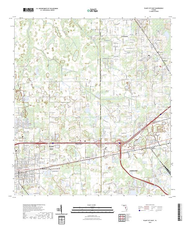 2024 Plant City East2024 Print · USGSThe corridor between Plant City and Lakeland comes into focus during this recent era of Florida's growth. Researchers can trace the development of small settlements like Youmans and Winston or locate the Mount Tabor Cem and Midway Lake Airport.
End of results
Showing maps 1-13 of 13
Top cities near Stalvey Oaks
- Tampa historical maps
- Lakeland historical maps
- Brandon historical maps
- Riverview historical maps
- Plant City historical maps
- Zephyrhills historical maps
See more
Frequently asked questions
- What are the different types of historical maps available for Stalvey Oaks?
- What is the oldest map of Stalvey Oaks?
- Where can I purchase historical maps of Stalvey Oaks for my home or office?
- Where can I download high-res historical maps of Stalvey Oaks?
- Are there historical topographic maps available for Stalvey Oaks?
- Is there historical aerial imagery available for Stalvey Oaks?
- Where are historical maps of Stalvey Oaks sourced from?