Old Maps of Tampa, Florida
Explore 91 old maps of Tampa, spanning from 1921 to today. These high-resolution historic maps reveal how streets, neighborhoods, landmarks, and natural features evolved over time — perfect for genealogy, metal detecting, research, and local history exploration.
What you can do with these maps:
- See how Tampa changed over time: Compare historical maps to modern-day views to trace roads, homesites, rail lines & more.
- View detailed metadata: Each map includes creators, publishers, year, scale, and archive source.
- Overlay maps with satellite & LiDAR: Visualize the past alongside modern tools to explore terrain & human change.
- Trusted historical sources: Maps sourced from the USGS, Library of Congress, and other archives.
- Access maps your way: View online, download high-res files, or order prints for personal or research use.
Start exploring old maps of Tampa to uncover forgotten places, hidden landmarks, and the deep history beneath your feet.
Tampa, FL maps
(91)- 1921 Map of Tampa
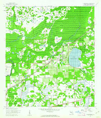
 1921 Tampa1921 Print · USGSCoastal Florida in the early twenties shows a landscape of growing towns and deep-water ports linked by expanding railroads. Genealogists and local historians can trace the early footprints of Ybor City, locate the Turpentine Still near Limona, and follow old routes like Bull Frog Road.
 - 1921 Map of St Petersburg
 1921 St Petersburg1921 Print · USGSThe Pinellas Peninsula just after the First World War shows a world of mangrove swamps, tidal bayous, and emerging settlements. Genealogists and local historians can trace early neighborhood footprints and coastal landmarks from Pinellas Park and Lealman to the growing streets of St. Petersburg.2 unique versions available
 - 1943 Map of Gandy Bridge
 1943 Gandy Bridge1943 Print · USGSHillsborough County's shoreline during the wartime mobilization shows a landscape of military ranges and emerging suburbs. Trace the development of Beach Park, the footprint of Drew Field, and the rail infrastructure of the Atlantic Coast Line.
 - 1943 Map of Port Tampa
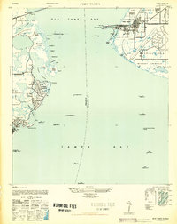
 1943 Port Tampa1943 Print · USGSThe Tampa Bay shoreline during World War II reveals a mix of wartime military expansion and early suburban development. Genealogists and historians can trace the foundations of Snell Isle, the industrial works at Port Tampa, and the early layout of MacDill Field.
 - 1943 Map of Thonotosassa, 1961 Print
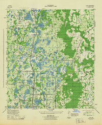
 1943 Thonotosassa1961 Print · USGSHillsborough County's landscape during the 1940s is defined by citrus groves and river wetlands centered around the massive Lake Thonotosassa. Researchers can trace old transportation routes and local landmarks like the Indian Sch, Missionary Ch, and the Hillsborough County Railroad.2 unique versions available
 - 1943 Map of Lutz, 1961 Print
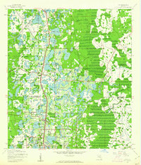 1943 Lutz1961 Print · USGSThe central Florida lake country comes into focus in the early 1940s as the rail-driven settlements of Lutz and Land O'Lakes began to take shape. Researchers can trace the early layout of Dupree Gardens, local churches like Drexel Ch, and the twin corridors of the Atlantic Coast Line and Seaboard Air Line.2 unique versions available
 - 1944 Map of Sulphur Springs
 1944 Sulphur Springs1944 Print · USGSNorth of Tampa during the mid-forties, this area shows a landscape of citrus groves and lakefront settlements before the post-war building boom. Genealogists can trace family roots through Lake Magdalene Cem, Oak Grove School, and the early streets of Sulphur Springs.
 - 1944 Map of Mango
 1944 Mango1944 Print · USGSHillsborough County's interior settlements and agricultural lands are captured here during the mid-forties. Researchers can trace family history through sites like St Marys Ch and Cem, the Levin Armwood School, and the early rail stops at Seffner and Mango.
 - 1944 Map of Tampa
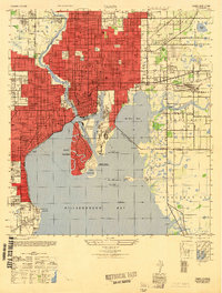
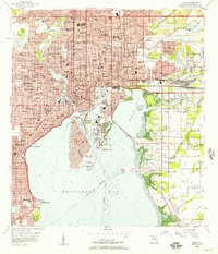
 1944 Tampa1944 Print · USGSTampa and the surrounding bayfront neighborhoods are shown during the mid-forties, capturing the city's transition into a modern maritime hub. Trace historical property lines and landmarks like Ybor City, Davis Islands, and the Peter O Knight Municipal Airport.
 - 1944 Map of Wesley Chapel
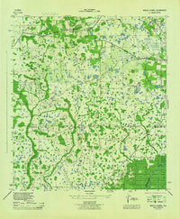 1944 Wesley Chapel1944 Print · USGSPasco and Hillsborough counties are shown during the mid-forties, characterized by scattered rural settlements and a dense network of creeks and cypress swamps. Researchers can trace the original locations of Wesley Chapel, Double Branch Church, and the Sulphur Works along the river banks.3 unique versions available
 - 1944 Map of Lutz
 1944 Lutz1944 Print · USGSFlorida's lake-strewn interior comes alive in the mid-1940s, showing the early rail and road networks of northern Hillsborough County. Genealogists and historians can trace the foundations of Lutz and Drexel, locating essential local landmarks like the Myrtle Denham School and the Drexel Station along the Atlantic Coast Line.
 - 1944 Map of Thonotosassa
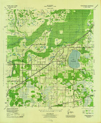 1944 Thonotosassa1944 Print · USGSHillsborough County during the 1940s reveals a transition from wetland wilderness to a networked rail-and-road economy. Genealogists can locate family landmarks such as Jolly Corner, the Indian School, and the Saffner Church along the Atlantic Coast Line.
 - 1945 Map of Gadsden Point
 1945 Gadsden Point1945 Print · USGSThe eastern shores of Tampa Bay are captured here during the height of the Second World War. Researchers can trace the layout of Macdill Field, the coastal facilities at Gadsden Point, and small established communities like Gibsonton and Adamsville.
 - 1945 Map of Sulphur Springs
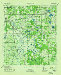
 1945 Sulphur Springs1945 Print · USGSHillsborough County's northern suburbs and lake districts emerge in the mid-1940s as the riverfront expands toward the citrus groves. Genealogists and historians can locate the Lake Carrol Cem, trace the Atlantic Coast Line tracks, or find the early airfield at Henderson-Hillsborough International Airport.
 - 1947 Map of Tampa
 1947 Tampa1947 Print · USGSTampa and its harbor districts appear here in the late Forties as the city's rail and maritime industries reached a mid-century peak. Genealogists and historians can trace the old street grids of Ybor City, locate family plots in Rose Hill Cem, and see early aviation at Peter O Knight Municipal Airport.2 unique versions available
 - 1947 Map of Port Tampa
 1947 Port Tampa1947 Print · USGSThe Florida coast just after the war shows the expansion of military and maritime infrastructure along Old Tampa Bay. Genealogists and historians can trace the early layouts of Shore Acres and Snell Isle or locate landmarks like the Port Tampa Dock.3 unique versions available
 - 1947 Map of Gandy Bridge
 1947 Gandy Bridge1947 Print · USGSHillsborough County's coastline and military landscape are captured here in the years following World War II. Researchers can trace the development of Drew Field and early residential subdivisions like Beach Park and Bel Mar along Old Tampa Bay.2 unique versions available
 - 1947 Map of Gadsden Point
 1947 Gadsden Point1947 Print · USGSCoastal Hillsborough County is captured here just after the war, showing the expansion of Mac Dill Field and the fishing villages of the eastern bay. Trace old family sites in Gibsonton and Adamsville or locate the historic U S Quarantine Station.
 - 1949 Map of Sulphur Springs
 1949 Sulphur Springs1949 Print · USGSHillsborough County in the late 1940s shows the growth of Sulphur Springs and Tampa northward into a lake-filled landscape. Researchers can find old community hubs like Oak Grove School, the Lake-Carrol Cem, and the early footprint of the Henderson-Hillsborough International Airport.
 - 1955 Map of Plant City, 1966 Print
 1955 Plant City1966 Print · USGSMid-century Central Florida comes to life in this survey of the Nature Coast and the inland citrus and rail belt. Genealogists and historians can trace the paths of the Atlantic Coast Line, locate the Anclote Keys Lighthouse, or find old communities like Masaryktown and Lacoochee.6 unique versions available
 - 1956 Map of Tampa, 1957 Print
 1956 Tampa1957 Print · USGSTampa and its bustling waterfront districts are shown in high detail during the mid-fifties as the city’s rail and port infrastructure reached its peak. Researchers can trace the heritage of Ybor City or locate family plots in Myrtle Hill Cemetery and Centro Espanol Cem.4 unique versions available
 - 1956 Map of Gandy Bridge, 1957 Print
 1956 Gandy Bridge1957 Print · USGSThe Tampa waterfront and Interbay Peninsula are seen here during a period of post-war suburban expansion. Genealogists and local historians can trace mid-century growth through schools like Plant High Sch and industrial sites at Rattlesnake.6 unique versions available
 - 1956 Map of Sulphur Springs, 1957 Print
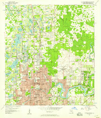 1956 Sulphur Springs1957 Print · USGSHillsborough County transitions from rural hammocks to suburban expansion in the mid-fifties as the Tampa area grows northward. Researchers can trace family history through sites like Lake Magdalene Ch, Nowatney, and the abandoned Henderson Hillsborough International Airport.4 unique versions available
 - 1956 Map of Gibsonton, 1957 Print
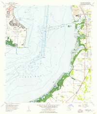 1956 Gibsonton1957 Print · USGSHillsborough Bay in the mid-1950s shows the strategic footprint of Mac Dill Air Force Base alongside a developing eastern shoreline. Genealogists and historians can trace the early layout of Gibsonton, Gardenville, and Adamsville along the Atlantic Coast Line railroad.6 unique versions available
 - 1956 Map of Port Tampa, 1957 Print
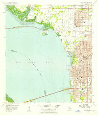
 1956 Port Tampa1957 Print · USGSThe Tampa Bay shoreline was a hub of military and industrial activity in the mid-fifties, with the sprawling Mac Dill Air Force Base facing the growing suburbs of St Petersburg. Researchers can trace the era's infrastructure from the Gandy Bridge to the rail-fed Port Tampa Dock.6 unique versions available
Showing maps 1-25 of 91
Top cities near Tampa
- Saint Petersburg historical maps
- Brandon historical maps
- Riverview historical maps
- Temple Terrace historical maps
- Lutz historical maps
- Feather Sound historical maps
Top neighborhoods of Tampa
- Arlington Heights historical maps
- Alameda historical maps
- Arlington Heights West historical maps
- Alice Heights historical maps
- Allerton Park historical maps
- Armenia Gardens historical maps
See more
Frequently asked questions
- What are the different types of historical maps available for Tampa?
- What is the oldest map of Tampa?
- Where can I purchase historical maps of Tampa for my home or office?
- Where can I download high-res historical maps of Tampa?
- Are there historical topographic maps available for Tampa?
- Is there historical aerial imagery available for Tampa?
- Where are historical maps of Tampa sourced from?