1950s Maps of Tampa, Florida
Explore 11 historic maps of Tampa from the 1950s. These maps offer a rare glimpse into what life looked like during the 1950s — showing old roads, neighborhoods, homes, and landmarks that have changed or disappeared over time.
Whether you're researching your family's past, planning a metal detecting trip, or studying how Tampa's landscape evolved across the 1950s, these high-resolution maps are a powerful tool for exploring the history of this region.
- Focus on a specific era: All maps on this page are from the 1950s, giving you a focused view of this time period.
- See what’s changed: Compare century-old streets, trails, and buildings to today's modern landscape using overlays and satellite layers.
- Research with precision: Use these maps for genealogy, historical research, land use analysis, or educational projects.
- View, download, or print: Maps are fully viewable online in high resolution, and can be downloaded or printed for your own records.
Start exploring Tampa's history through authentic maps from the 1950s. This is your window into the past.
Tampa, FL maps
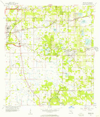
(11)- 1955 Map of Plant City, 1966 Print
 1955 Plant City1966 Print · USGSMid-century Central Florida comes to life in this survey of the Nature Coast and the inland citrus and rail belt. Genealogists and historians can trace the paths of the Atlantic Coast Line, locate the Anclote Keys Lighthouse, or find old communities like Masaryktown and Lacoochee.6 unique versions available
 - 1956 Map of Tampa, 1957 Print
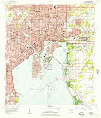 1956 Tampa1957 Print · USGSTampa and its bustling waterfront districts are shown in high detail during the mid-fifties as the city’s rail and port infrastructure reached its peak. Researchers can trace the heritage of Ybor City or locate family plots in Myrtle Hill Cemetery and Centro Espanol Cem.4 unique versions available
 - 1956 Map of Gandy Bridge, 1957 Print
 1956 Gandy Bridge1957 Print · USGSThe Tampa waterfront and Interbay Peninsula are seen here during a period of post-war suburban expansion. Genealogists and local historians can trace mid-century growth through schools like Plant High Sch and industrial sites at Rattlesnake.6 unique versions available
 - 1956 Map of Sulphur Springs, 1957 Print
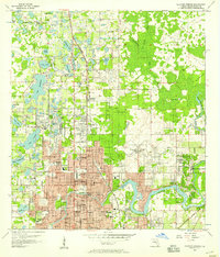 1956 Sulphur Springs1957 Print · USGSHillsborough County transitions from rural hammocks to suburban expansion in the mid-fifties as the Tampa area grows northward. Researchers can trace family history through sites like Lake Magdalene Ch, Nowatney, and the abandoned Henderson Hillsborough International Airport.4 unique versions available
 - 1956 Map of Gibsonton, 1957 Print
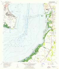 1956 Gibsonton1957 Print · USGSHillsborough Bay in the mid-1950s shows the strategic footprint of Mac Dill Air Force Base alongside a developing eastern shoreline. Genealogists and historians can trace the early layout of Gibsonton, Gardenville, and Adamsville along the Atlantic Coast Line railroad.6 unique versions available
 - 1956 Map of Port Tampa, 1957 Print
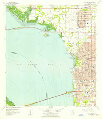
 1956 Port Tampa1957 Print · USGSThe Tampa Bay shoreline was a hub of military and industrial activity in the mid-fifties, with the sprawling Mac Dill Air Force Base facing the growing suburbs of St Petersburg. Researchers can trace the era's infrastructure from the Gandy Bridge to the rail-fed Port Tampa Dock.6 unique versions available
 - 1956 Map of Brandon, 1957 Print
 1956 Brandon1957 Print · USGSCentral Florida in the mid-fifties shows a landscape of citrus-era rail towns and numerous inland lakes. Trace the early footprints of Brandon and Riverview, or find family landmarks like Providence Ch and the Alafia River corridor.5 unique versions available
 - 1956 Map of Tampa, 1964 Print
 1956 Tampa1964 Print · USGSThe Florida Gulf Coast thrived in the mid-fifties, from the bustling docks of Tampa to the quiet shores of Sanibel. Genealogists and historians can trace old rail lines like the Atlantic Coast Line or find early layouts of Port Charlotte and Bokeelia.2 unique versions available
 - 1958 Map of Plant City
 1958 Plant City1958 Print · USGSFlorida's Gulf Coast and inland ridge country are captured here in the mid-fifties, showing the region before modern sprawl. Genealogists and historians can trace rail-era towns like Richland and Trilby or locate coastal landmarks such as the Anclote Keys Lighthouse.
 - 1959 Map of Plant City
 1959 Plant City1959 Print · USGSThe West Florida coast and inland timberlands are captured here in the late fifties, from the bend of the Gulf to the rail hubs of the interior. Trace the paths of the Atlantic Coast Line through Inverness and find landmarks like the Anclote Keys Lighthouse.
 - 1959 Map of Tampa
 1959 Tampa1959 Print · USGSThe Florida Gulf Coast appears in this late fifties survey during a period of steady coastal growth and established rail commerce. Researchers can trace historic neighborhoods and transit lines from Tampa to St Petersburg, or locate landmarks like Mac Dill AFB and Boca Grande.
End of results
Showing maps 1-11 of 11
Top cities near Tampa
- Saint Petersburg historical maps
- Brandon historical maps
- Riverview historical maps
- Temple Terrace historical maps
- Lutz historical maps
- Feather Sound historical maps
Top neighborhoods of Tampa
- Arlington Heights historical maps
- Alameda historical maps
- Arlington Heights West historical maps
- Alice Heights historical maps
- Allerton Park historical maps
- Armenia Gardens historical maps
See more
Frequently asked questions
- What are the different types of historical maps available for Tampa?
- What is the oldest map of Tampa?
- Where can I purchase historical maps of Tampa for my home or office?
- Where can I download high-res historical maps of Tampa?
- Are there historical topographic maps available for Tampa?
- Is there historical aerial imagery available for Tampa?
- Where are historical maps of Tampa sourced from?