1940s Maps of Temple Terrace, Hillsborough County
Explore 5 historic maps of Temple Terrace from the 1940s. These maps offer a rare glimpse into what life looked like during the 1940s — showing old roads, neighborhoods, homes, and landmarks that have changed or disappeared over time.
Whether you're researching your family's past, planning a metal detecting trip, or studying how Temple Terrace's landscape evolved across the 1940s, these high-resolution maps are a powerful tool for exploring the history of this region.
- Focus on a specific era: All maps on this page are from the 1940s, giving you a focused view of this time period.
- See what’s changed: Compare century-old streets, trails, and buildings to today's modern landscape using overlays and satellite layers.
- Research with precision: Use these maps for genealogy, historical research, land use analysis, or educational projects.
- View, download, or print: Maps are fully viewable online in high resolution, and can be downloaded or printed for your own records.
Start exploring Temple Terrace's history through authentic maps from the 1940s. This is your window into the past.
Temple Terrace, Hillsborough County maps
(5)- 1943 Map of Thonotosassa, 1961 Print
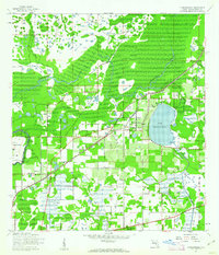 1943 Thonotosassa1961 Print · USGSHillsborough County's landscape during the 1940s is defined by citrus groves and river wetlands centered around the massive Lake Thonotosassa. Researchers can trace old transportation routes and local landmarks like the Indian Sch, Missionary Ch, and the Hillsborough County Railroad.2 unique versions available
 - 1944 Map of Sulphur Springs
 1944 Sulphur Springs1944 Print · USGSNorth of Tampa during the mid-forties, this area shows a landscape of citrus groves and lakefront settlements before the post-war building boom. Genealogists can trace family roots through Lake Magdalene Cem, Oak Grove School, and the early streets of Sulphur Springs.
 - 1944 Map of Thonotosassa
 1944 Thonotosassa1944 Print · USGSHillsborough County during the 1940s reveals a transition from wetland wilderness to a networked rail-and-road economy. Genealogists can locate family landmarks such as Jolly Corner, the Indian School, and the Saffner Church along the Atlantic Coast Line.
 - 1945 Map of Sulphur Springs
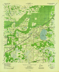
 1945 Sulphur Springs1945 Print · USGSHillsborough County's northern suburbs and lake districts emerge in the mid-1940s as the riverfront expands toward the citrus groves. Genealogists and historians can locate the Lake Carrol Cem, trace the Atlantic Coast Line tracks, or find the early airfield at Henderson-Hillsborough International Airport.
 - 1949 Map of Sulphur Springs
 1949 Sulphur Springs1949 Print · USGSHillsborough County in the late 1940s shows the growth of Sulphur Springs and Tampa northward into a lake-filled landscape. Researchers can find old community hubs like Oak Grove School, the Lake-Carrol Cem, and the early footprint of the Henderson-Hillsborough International Airport.
End of results
Showing maps 1-5 of 5
Frequently asked questions
- What are the different types of historical maps available for Temple Terrace?
- What is the oldest map of Temple Terrace?
- Where can I purchase historical maps of Temple Terrace for my home or office?
- Where can I download high-res historical maps of Temple Terrace?
- Are there historical topographic maps available for Temple Terrace?
- Is there historical aerial imagery available for Temple Terrace?
- Where are historical maps of Temple Terrace sourced from?