
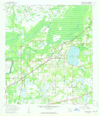
1943 Map of Thonotosassa
USGS Topo · Published 1961About this map
Lake Thonotosassa dominates the eastern half of this 1943 landscape, surrounded by an intricate network of wetlands and citrus groves that defined the region during the mid-century. The Hillsborough River meanders across the northern section, while the Atlantic Coast Line railroad provides a critical transportation spine through the center of the sheet. Settlements like Clarkwild and Thonotosassa show the early residential and agricultural development patterns of Hillsborough County before the massive suburban expansion of later decades.
Find a feature on this map
24 named features on this map. Tap any name to fly to it.
Don’t see what you’re looking for? This feature index may not catch every label — zoom into the map to look around manually.
Map Details
Editions of this 1943 Thonotosassa Map
2 editions found
Other maps of this area

1921 · Tampa
USGS Topo · 1:62,500

1943 · Lutz
USGS Topo · 1:24,000

1944 · Sulphur Springs
USGS Topo · 1:31,680

1944 · Mango
USGS Topo · 1:31,680

1944 · Tampa
USGS Topo · 1:31,680

1944 · Wesley Chapel
USGS Topo · 1:31,680

1944 · Lutz
USGS Topo · 1:31,680

1944 · Thonotosassa
USGS Topo · 1:31,680

1944 · Antioch
USGS Topo · 1:31,680

1945 · Sulphur Springs
USGS Topo · 1:31,680