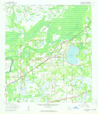
1943 Map of Thonotosassa
USGS Topo · Published 1961About this map
Lake Thonotosassa dominates this landscape northeast of Tampa, where the Hillsborough River and its tributaries define the regional drainage. The mid-century geography reveals a transition from the developing community of Temple Terrace to rural settlements and citrus-growing areas. Local life is anchored by small community hubs such as Clarkwild and Jolly Corner, while the Atlantic Coast Line railroad provides the primary industrial link through the territory. Cultural landmarks, including the Thonotosassa Sch and Indian Sch, reflect the era's social infrastructure alongside several country churches. The map also documents the expanse of Harney Flats and the convergence of waterways like Cow House Creek and Sixmile Creek before the widespread suburban expansion of later decades.
Find a feature on this map
22 named features on this map. Tap any name to fly to it.
Don’t see what you’re looking for? This feature index may not catch every label — zoom into the map to look around manually.
Map Details
Editions of this 1943 Thonotosassa Map
2 editions found
Other maps of this area

1921 · Tampa
USGS Topo · 1:62,500

1943 · Thonotosassa
USGS Topo · 1:24,000

1943 · Lutz
USGS Topo · 1:24,000

1944 · Sulphur Springs
USGS Topo · 1:31,680

1944 · Mango
USGS Topo · 1:31,680

1944 · Tampa
USGS Topo · 1:31,680

1944 · Wesley Chapel
USGS Topo · 1:31,680

1944 · Lutz
USGS Topo · 1:31,680

1944 · Thonotosassa
USGS Topo · 1:31,680

1944 · Antioch
USGS Topo · 1:31,680