Old Maps of Leonia, Florida for Metal Detecting
Plan your next treasure hunt with 13 historic maps of Leonia. Find old homesites, ghost towns, trails, and gathering spots that may be lost to time — perfect for identifying promising metal detecting locations.
- Locate forgotten sites: Uncover places like long-lost settlements, abandoned rail lines, or gathering spots.
- Plan better hunts: Use map overlays combined with LiDAR or satellite views to narrow in on historically rich areas.
- Made for detectorists: Thousands of hobbyists use these maps to discover relics, coins, and hidden history.
Use these historic maps to boost your research and find new opportunities beneath the surface of Leonia.
Leonia, FL maps
(13)- 1949 Map of Glendale
 1949 Glendale1949 Print · USGSNorthern Walton County in the late 1940s reveals a landscape of isolated turpentine stills and rural congregations. Trace family roots at Halls Still, Darlington, and Limestone Cem while exploring the wetlands of Big Swamp.
 - 1951 Map of Glendale
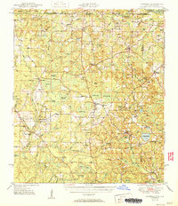 1951 Glendale1951 Print · USGSThe Alabama-Florida borderlands come to life in this mid-century survey of the pine-studded interior. Genealogists and local historians can trace family-named landmarks like Braxton Cem and old community hubs including Gaskin, Glendale, and Limestone Ch.2 unique versions available
 - 1957 Map of Pensacola, 1967 Print
 1957 Pensacola1967 Print · USGSThe Florida Panhandle and Alabama coast are seen here at the height of the Cold War, showcasing a unique mix of military aviation and emerging beach tourism. Genealogists and local historians can trace legacy sites like Old Corry Field, the lumber town of Bagdad, and the coastal reaches of Santa Rosa Island.3 unique versions available
 - 1959 Map of Pensacola
 1959 Pensacola1959 Print · USGSThe Florida Panhandle and Alabama coast come alive in this late fifties survey of military aviation and maritime life. Genealogists can trace family roots in Bagdad, Loxley, and Milton while mapping the rails of the Louisville and Nashville.
 - 1960 Map of Pensacola
 1960 Pensacola1960 Print · USGSThe Florida Panhandle and Alabama's eastern shore are shown during a period of rapid military and coastal growth. Genealogists and historians can trace the mid-century footprints of Warrington, the Pensacola NAS (Chevalier), and the Blackwater River timber lands.
 - 1973 Map of Darlington, 1975 Print
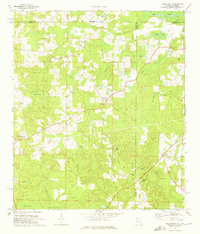 1973 Darlington1975 Print · USGSThe Florida-Alabama borderlands come into focus in the early 1970s, showing a landscape of timbered bays and quiet rural hamlets. Genealogists can trace family roots through several local landmarks like Oak Grove Ch, Limestone Cem, and Padgett Cem.2 unique versions available
 - 1978 Map of Crestview, 1982 Print
 1978 Crestview1982 Print · USGSThe Florida Panhandle and southern Alabama borderlands appear here in the late seventies as the military and timber industries shaped the landscape. Genealogists can trace family roots through small settlements like Cannon Town or Svea, and locate old sites like Aux Field No 4 (Abandoned).2 unique versions available
 - 1987 Map of Darlington, 1993 Print
 1987 Darlington1993 Print · USGSIn the late twentieth century, this North Florida borderland was a patchwork of small communities and family-named cemeteries. Researchers can trace rural settlement patterns through sites like the Limestone Cem, the village of Darlington, and the wetlands of Peavey Bay.
 - 2012 Map of Darlington, 2012 Print
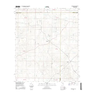
 2012 Darlington2012 Print · USGSCovers Leonia, including Darlington, Walton County, and other nearby areas
 - 2015 Map of Darlington, 2015 Print
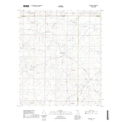
 2015 Darlington2015 Print · USGSCovers Leonia, including Darlington, Walton County, and other nearby areas
 - 2018 Map of Darlington, 2018 Print
 2018 Darlington2018 Print · USGSCovers Leonia, including Darlington, Walton County, and other nearby areas
 - 2021 Map of Darlington, 2021 Print
 2021 Darlington2021 Print · USGSCovers Leonia, including Darlington, Walton County, and other nearby areas
 - 2024 Map of Darlington, 2024 Print
 2024 Darlington2024 Print · USGSThe rural borderlands of Walton County come into focus in this recent survey of the Florida-Alabama state line. Researchers can trace established family roots and local landmarks through sites like Leonia, Limestone Church Cem, and Carroll Family Cem.
End of results
Showing maps 1-13 of 13
Top cities near Leonia
- DeFuniak Springs historical maps
- Geneva historical maps
- Samson historical maps
- Ponce de Leon historical maps
- Eunola historical maps
- Caryville historical maps
See more
Frequently asked questions
- What are the different types of historical maps available for Leonia?
- What is the oldest map of Leonia?
- Where can I purchase historical maps of Leonia for my home or office?
- Where can I download high-res historical maps of Leonia?
- Are there historical topographic maps available for Leonia?
- Is there historical aerial imagery available for Leonia?
- Where are historical maps of Leonia sourced from?