Old Maps of Holmes County, Florida
Explore 136 old maps of Holmes County, spanning from 1935 to today. These high-resolution historic maps reveal how streets, neighborhoods, landmarks, and natural features evolved over time — perfect for genealogy, metal detecting, research, and local history exploration.
What you can do with these maps:
- See how Holmes County changed over time: Compare historical maps to modern-day views to trace roads, homesites, rail lines & more.
- View detailed metadata: Each map includes creators, publishers, year, scale, and archive source.
- Overlay maps with satellite & LiDAR: Visualize the past alongside modern tools to explore terrain & human change.
- Trusted historical sources: Maps sourced from the USGS, Library of Congress, and other archives.
- Access maps your way: View online, download high-res files, or order prints for personal or research use.
Start exploring old maps of Holmes County to uncover forgotten places, hidden landmarks, and the deep history beneath your feet.
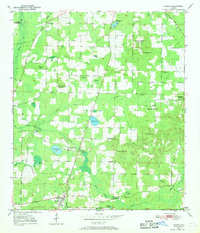
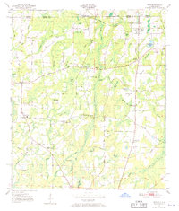
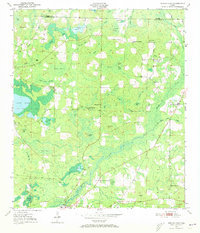
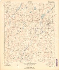
Holmes County, FL maps
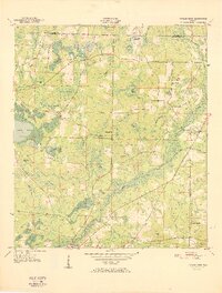
(136)- 1935 Map of De Funiak Springs
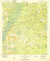
 1935 De Funiak Springs1935 Print · USGSWalton County in the mid-1930s shows a landscape of rural schools and family homesteads centered around the rail hub of De Funiak Springs. Genealogists can trace family locations near Magnolia Cem, Seckinger Mill, and the many one-room schoolhouses like Indian Head Sch.2 unique versions available
 - 1938 Map of De Funiak Springs
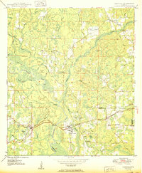
 1938 De Funiak Springs1938 Print · USGSWalton County in the late thirties is a landscape of creek-side mills and timberlands stretching from the Louisville and Nashville RR down to the bay. Genealogists can locate family landmarks like Oak Ridge Cem, trace old routes at Old Walton Bridge, and find rural school sites like Eucheanna Sch.4 unique versions available
 - 1948 Map of Ponce De Leon, 1970 Print
 1948 Ponce De Leon1970 Print · USGSThe Florida Panhandle is captured here in the late 1940s, showing a landscape defined by natural springs and the crossroads of the Old Spanish Trail. Researchers can locate family landmarks like Knox Hill Sch, Hardy Cem, and the settlement of Ponce de Leon.
 - 1949 Map of Glendale
 1949 Glendale1949 Print · USGSNorthern Walton County in the late 1940s reveals a landscape of isolated turpentine stills and rural congregations. Trace family roots at Halls Still, Darlington, and Limestone Cem while exploring the wetlands of Big Swamp.
 - 1949 Map of Hinsons Cross Roads, 1972 Print
 1949 Hinsons Cross Roads1972 Print · USGSFlorida Panhandle life in the late 1940s centers on the river bends and rural intersections where the boundaries of Washington, Holmes, and Walton counties meet. Researchers can trace family ties through community landmarks like Hinsons Cross Roads, Davis Sch, and New Bethany Ch.
 - 1949 Map of Hobbs Crossroads, 1973 Print
 1949 Hobbs Crossroads1973 Print · USGSThe Alabama-Florida state line meets in the late 1940s near rural hubs and bayous. Researchers can trace family sites like McDuffie Cem and find old gathering places like Barker Store or the Poplar Head Ch.
 - 1949 Map of Caryville, 1973 Print
 1949 Caryville1973 Print · USGSThe Choctawhatchee River floodplain in the late 1940s reveals a landscape of winding sloughs and rail-side settlements. Genealogists can trace family names at Westville Cem and Dyson Cem or locate rural schools like New Prospect Sch and Union Sch.
 - 1950 Map of Hobbs Cross Roads
 1950 Hobbs Cross Roads1950 Print · USGSThe Florida-Alabama state line at mid-century was a region of river landings and remote crossroad communities. Genealogists can trace family footprints through sites like McDuffie Cem, Beulah Anna Ch, and the old river access at Old Warehouse Landing.2 unique versions available
 - 1950 Map of Prosperity
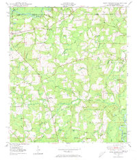
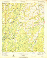
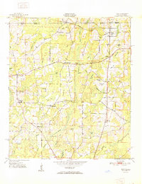
 1950 Prosperity1950 Print · USGSHolmes County in the early post-war years remained a landscape of timbered bays and scattered family settlements connected by the Old Spanish Trail. Researchers can trace the footprints of Arrant Settlement, Prosperity, and historic churches like Corinth Ch.3 unique versions available
 - 1950 Map of Ponce De Leon
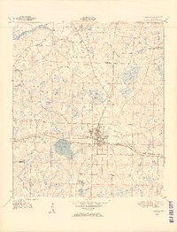
 1950 Ponce De Leon1950 Print · USGSFlorida's Panhandle is captured here at mid-century, where the Louisville and Nashville railroad meets the winding Choctawhatchee River. Researchers can locate old community landmarks like Douglas Crossroad, Knox Hill Sch, and the historic Old Spanish Trail.
 - 1950 Map of Hinsons Cross Roads
 1950 Hinsons Cross Roads1950 Print · USGSFlorida's Panhandle is documented here at the midpoint of the century, showing the rural intersections of Washington, Holmes, and Walton counties. Genealogists can trace local landmarks like St Matthews Ch, Clarkston Cem, and the community at Hinsons Cross Roads.
 - 1950 Map of Caryville
 1950 Caryville1950 Print · USGSThe Choctawhatchee River lowlands come to life in this 1950s survey of the Holmes and Washington border. Genealogists can locate family landmarks like Blackman Cem, Forehand Cem, and schools in Gritney or Winterville.
 - 1950 Map of Izagora
 1950 Izagora1950 Print · USGSThe Choctawhatchee River valley at the Florida-Alabama border reveals a mid-century landscape of riverfront landings and rural settlements. Trace family roots and local history at Izagora, Curry Ferry, and numerous country churches like Mt Ada Ch.2 unique versions available
 - 1950 Map of Chipley, 1966 Print
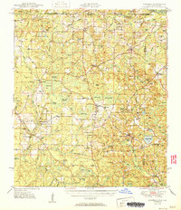
 1950 Chipley1966 Print · USGSMid-century Florida panhandle life unfolds in this survey of the region where the railroad meets the Old Spanish Trail. Genealogists and historians can trace the rural landscape through Richter Crossroads, Mt Zion Cem, and the Chipley Landing Field.
 - 1950 Map of Wausau, 1968 Print
 1950 Wausau1968 Print · USGSWashington County during the early post-war years reveals a landscape of dispersed farmsteads and rural schoolhouses. Genealogists can locate family landmarks such as Bells Mill, Orange Hill Corners, and several rural burial grounds like Bradford Cem.
 - 1950 Map of Esto, 1970 Print
 1950 Esto1970 Print · USGSThe Florida-Alabama borderlands at the mid-century mark reveal a landscape of crossroads settlements and wetland bays connected by the Louisville and Nashville railroad. Researchers can locate vanished rural landmarks like the Bethlehem School, Double Springs Cemetery, and the Hog and Hominy Road.
 - 1950 Map of Poplar Head, 1973 Print
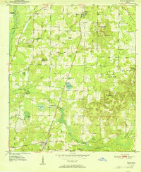
 1950 Poplar Head1973 Print · USGSMid-century Washington and Holmes Counties are defined here by the winding Holmes Creek and a labyrinth of timbered bays. Genealogists can locate family landmarks like Johnson Crossroad, Union Hill Sch, and the Bethesda Ch.
 - 1951 Map of Graceville
 1951 Graceville1951 Print · USGSGraceville and the surrounding Florida-Alabama borderlands are captured here during the early fifties, showing a landscape of timber and rail. Researchers can trace family roots through numerous local landmarks like Liberty Hill Ch, Poplar Springs Sch, and Collins Mill.2 unique versions available
 - 1951 Map of Esto
 1951 Esto1951 Print · USGSThe Florida-Alabama borderlands come into focus in the early 1950s, showing a landscape of timbered hills and rural crossroads. Genealogists can trace family footprints at the Bethlehem West Florida Camp Meeting Ground, Holland Crossroads, and Bethany Ch.
 - 1951 Map of Glendale
 1951 Glendale1951 Print · USGSThe Alabama-Florida borderlands come to life in this mid-century survey of the pine-studded interior. Genealogists and local historians can trace family-named landmarks like Braxton Cem and old community hubs including Gaskin, Glendale, and Limestone Ch.2 unique versions available
 - 1951 Map of Chipley
 1951 Chipley1951 Print · USGSChipley and its surrounding wetlands are captured here at the start of the 1950s, showing a landscape defined by the railroad and the Old Spanish Trail. Genealogists and local historians can locate early family landmarks like Richter Crossroads, Salem Ch, and Mt Zion Cem.
 - 1951 Map of Wausau
 1951 Wausau1951 Print · USGSFlorida's Panhandle is documented here in the early fifties, showing the rural communities of Washington and Holmes counties before modern development. Researchers can trace ancestral roots through sites like Everett Cem, Oak Grove Sch, and the community of Wausau.
 - 1951 Map of Poplar Head
 1951 Poplar Head1951 Print · USGSThe Florida Panhandle in the early fifties shows a landscape of expansive bays and rural crossroads. Genealogists and local historians can trace family locations near Union Hill Sch, Bethesda Ch, and the settlement at Poplar Head.
 - 1951 Map of Bonifay
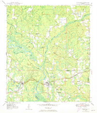
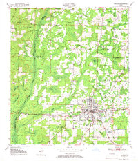
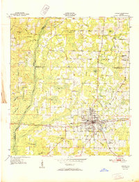
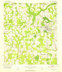
 1951 Bonifay1951 Print · USGSBonifay thrived at the intersection of rail and road in the mid-century Florida Panhandle. Genealogists and local historians can trace the foundations of rural life through landmarks like Hoover Mill, Live Oak Sch Cem, and the Old Spanish Trail.3 unique versions available
 - 1952 Map of Campbellton, 1953 Print
 1952 Campbellton1953 Print · USGSJackson County and the Florida-Alabama border are captured here in the early fifties, centered on the rail-fed hub of Campbellton. Genealogists can trace rural community life through numerous local landmarks like Hinson Cem, Shiloh Sch, and Ellaville.2 unique versions available
Showing maps 1-25 of 136
Top cities of Holmes County
- Bonifay historical maps
- Ponce de Leon historical maps
- Esto historical maps
- Westville historical maps
- Noma historical maps
Frequently asked questions
- What are the different types of historical maps available for Holmes County?
- What is the oldest map of Holmes County?
- Where can I purchase historical maps of Holmes County for my home or office?
- Where can I download high-res historical maps of Holmes County?
- Are there historical topographic maps available for Holmes County?
- Is there historical aerial imagery available for Holmes County?
- Where are historical maps of Holmes County sourced from?