1970s Maps of Holmes County, Florida
Explore 5 historic maps of Holmes County from the 1970s. These maps offer a rare glimpse into what life looked like during the 1970s — showing old roads, neighborhoods, homes, and landmarks that have changed or disappeared over time.
Whether you're researching your family's past, planning a metal detecting trip, or studying how Holmes County's landscape evolved across the 1970s, these high-resolution maps are a powerful tool for exploring the history of this region.
- Focus on a specific era: All maps on this page are from the 1970s, giving you a focused view of this time period.
- See what’s changed: Compare century-old streets, trails, and buildings to today's modern landscape using overlays and satellite layers.
- Research with precision: Use these maps for genealogy, historical research, land use analysis, or educational projects.
- View, download, or print: Maps are fully viewable online in high resolution, and can be downloaded or printed for your own records.
Start exploring Holmes County's history through authentic maps from the 1970s. This is your window into the past.
Holmes County, FL maps
(5)- 1973 Map of Darlington, 1975 Print
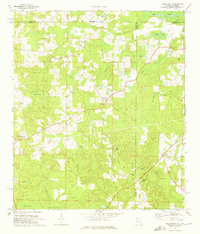 1973 Darlington1975 Print · USGSThe Florida-Alabama borderlands come into focus in the early 1970s, showing a landscape of timbered bays and quiet rural hamlets. Genealogists can trace family roots through several local landmarks like Oak Grove Ch, Limestone Cem, and Padgett Cem.2 unique versions available
 - 1973 Map of Glendale, 1976 Print
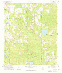 1973 Glendale1976 Print · USGSThe Florida Panhandle interior during the early seventies is recorded here, showing the rural communities along the Walton and Holmes county border. Genealogists can locate family landmarks such as Gum Creek Ch, Pleasant Grove, and the State Fish Hatchery at Lake Cassidy.2 unique versions available
 - 1973 Map of De Funiak Springs East, 1976 Print
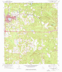 1973 De Funiak Springs East1976 Print · USGSWalton County in the early seventies centers on the rail-driven growth of De Funiak Springs and the historic settlement of Eucheeanna. Genealogists and historians can trace local landmarks like Magnolia Cem, Euchee Valley Ch, and the Louisville and Nashville line.2 unique versions available
 - 1978 Map of Crestview, 1982 Print
 1978 Crestview1982 Print · USGSThe Florida Panhandle and southern Alabama borderlands appear here in the late seventies as the military and timber industries shaped the landscape. Genealogists can trace family roots through small settlements like Cannon Town or Svea, and locate old sites like Aux Field No 4 (Abandoned).2 unique versions available
 - 1979 Map of Marianna, 1980 Print
 1979 Marianna1980 Print · USGSFlorida's northern panhandle and the neighboring Alabama-Georgia borderlands are captured here in the late seventies. Genealogists and local historians can trace family roots through settlements like Graceville and Cottondale or follow the historic Louisville and Nashville rail lines.2 unique versions available
End of results
Showing maps 1-5 of 5
Top cities of Holmes County
- Bonifay historical maps
- Ponce de Leon historical maps
- Esto historical maps
- Westville historical maps
- Noma historical maps
Frequently asked questions
- What are the different types of historical maps available for Holmes County?
- What is the oldest map of Holmes County?
- Where can I purchase historical maps of Holmes County for my home or office?
- Where can I download high-res historical maps of Holmes County?
- Are there historical topographic maps available for Holmes County?
- Is there historical aerial imagery available for Holmes County?
- Where are historical maps of Holmes County sourced from?