1980s Maps of Holmes County, Florida
Explore 15 historic maps of Holmes County from the 1980s. These maps offer a rare glimpse into what life looked like during the 1980s — showing old roads, neighborhoods, homes, and landmarks that have changed or disappeared over time.
Whether you're researching your family's past, planning a metal detecting trip, or studying how Holmes County's landscape evolved across the 1980s, these high-resolution maps are a powerful tool for exploring the history of this region.
- Focus on a specific era: All maps on this page are from the 1980s, giving you a focused view of this time period.
- See what’s changed: Compare century-old streets, trails, and buildings to today's modern landscape using overlays and satellite layers.
- Research with precision: Use these maps for genealogy, historical research, land use analysis, or educational projects.
- View, download, or print: Maps are fully viewable online in high resolution, and can be downloaded or printed for your own records.
Start exploring Holmes County's history through authentic maps from the 1980s. This is your window into the past.
Holmes County, FL maps
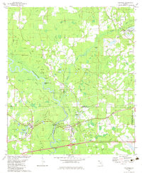
(15)- 1982 Map of Campbellton
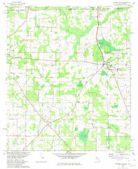 1982 Campbellton1982 Print · USGSJackson County and the Florida-Alabama border appear here in the early eighties as a landscape of crossroads settlements and small-town junctions. Genealogists can trace family landmarks like Hinson Cem and Salem Ch along the Atlanta and Saint Andrews Bay rail line.2 unique versions available
 - 1982 Map of Hinsons Crossroads
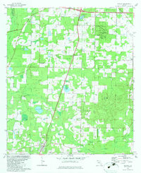
 1982 Hinsons Crossroads1982 Print · USGSThe Florida Panhandle's riverine landscape is meticulously documented here during the early eighties, centered on the Choctawhatchee River. Genealogists can locate family-named landmarks like Cooey Field and rural churches including New Bethany Ch and St Matthews Cem Ch.
 - 1982 Map of Hobbs Crossroads
 1982 Hobbs Crossroads1982 Print · USGSThe Florida-Alabama borderlands along the Pea River are captured here in the early eighties, showing a landscape of bay galls and rural settlements. Trace family roots at Sweet Gum Head Cemeteries or explore the river landings at Old Warehouse Landing.3 unique versions available
 - 1982 Map of Chipley
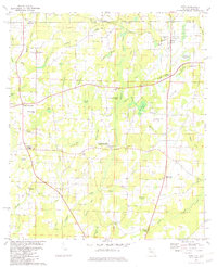
 1982 Chipley1982 Print · USGSChipley and its surrounding bayous are captured here in the early eighties as the town grew at the intersection of rail and road. Researchers can trace family roots at Limestone Cem, find the Richter Crossroads settlement, or locate the Tri County Airport.
 - 1982 Map of Bonifay
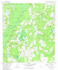
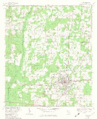
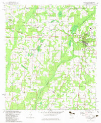
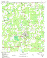 1982 Bonifay1982 Print · USGSBonifay and the surrounding Holmes County landscape are captured here in the early eighties, showing a region defined by its railroads and wetlands. Genealogists can locate several rural landmarks like Gully Springs Ch, Mt Olive Ch, and the Drive-In Theater.
 - 1982 Map of Caryville, 1983 Print
 1982 Caryville1983 Print · USGSCaryville and the surrounding Panhandle wetlands are captured here in the early eighties at the junction of the river and rail. Researchers can trace family roots at Westville Cem or locate rural centers like Gritney and Shady Grove Ch.
 - 1982 Map of Wausau, 1983 Print
 1982 Wausau1983 Print · USGSIn the early 1980s, the rural border between Holmes and Washington counties was defined by the transition from karst uplands to winding creek bottoms. Genealogists and local historians can trace legacy sites like Everett Cem, Hard Labor Ch, and the community of Orange Hill.
 - 1982 Map of Esto, 1983 Print
 1982 Esto1983 Print · USGSThe Florida-Alabama state line and the Holmes County border intersect here in the early eighties, anchoring a landscape of rural crossroads and cypress bays. Researchers can trace family history at the Bethlehem-West Florida Camp Meeting Ground and old burial sites like Double Springs Cem.2 unique versions available
 - 1982 Map of Graceville, 1983 Print
 1982 Graceville1983 Print · USGSThe Florida-Alabama borderlands come into focus in the early eighties, showcasing the agricultural and rail-oriented landscape around Graceville. Genealogists and historians can trace community roots at Cem Liberty Hill Ch, Damascus Ch, and the site of Collins Mill.2 unique versions available
 - 1982 Map of Poplar Head, 1983 Print
 1982 Poplar Head1983 Print · USGSNorthwest Florida's pine and swamp country comes alive in this early 1980s survey. Genealogists and local historians can trace the community around Vernon, locate family landmarks like Brock Crossroad, or find the secluded Cooks Mill Pond.
 - 1982 Map of Izagora, 1983 Print
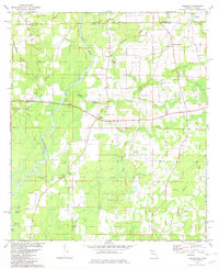 1982 Izagora1983 Print · USGSThe Florida-Alabama borderlands near the Choctawhatchee River come into focus in the early eighties, showing a landscape of scattered rural settlements and winding creeks. Genealogists can trace family roots at Izagora, Smith Crossroads, and several local landmarks like Midway Ch and Curry Cem.2 unique versions available
 - 1982 Map of Ponce De Leon, 1983 Print
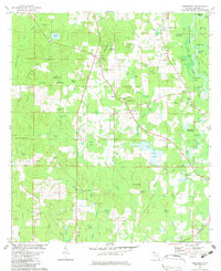
 1982 Ponce De Leon1983 Print · USGSThe Florida Panhandle comes into focus in the early eighties as a network of rural settlements and timberlands. Genealogists and researchers can trace local roots through numerous country landmarks including Knox Hill, Andrew Chapel, and Hardy Cem.2 unique versions available
 - 1982 Map of Prosperity, 1983 Print
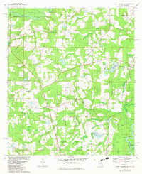
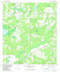
 1982 Prosperity1983 Print · USGSFlorida's panhandle countryside comes into focus in the early eighties, showing the Holmes County landscape before modern expansion. Genealogists can trace family roots through the Baker Settlement and Cerrogordo or locate rural landmarks like Evergreen Ch and Braxton Cem.
 - 1987 Map of Darlington, 1993 Print
 1987 Darlington1993 Print · USGSIn the late twentieth century, this North Florida borderland was a patchwork of small communities and family-named cemeteries. Researchers can trace rural settlement patterns through sites like the Limestone Cem, the village of Darlington, and the wetlands of Peavey Bay.
 - 1988 Map of Tallahassee
 1988 Tallahassee1988 Print · USGSThe Florida Panhandle and South Georgia are captured here in the late eighties, showing the expansion of the regional highway network and coastal growth. Genealogists and historians can trace rail lines like the Seaboard System Railroad or locate family roots in Blountstown, Graceville, or Crawfordville.2 unique versions available
End of results
Showing maps 1-15 of 15
Top cities of Holmes County
- Bonifay historical maps
- Ponce de Leon historical maps
- Esto historical maps
- Westville historical maps
- Noma historical maps
Frequently asked questions
- What are the different types of historical maps available for Holmes County?
- What is the oldest map of Holmes County?
- Where can I purchase historical maps of Holmes County for my home or office?
- Where can I download high-res historical maps of Holmes County?
- Are there historical topographic maps available for Holmes County?
- Is there historical aerial imagery available for Holmes County?
- Where are historical maps of Holmes County sourced from?