1990s Maps of Holmes County, Florida
Explore 5 historic maps of Holmes County from the 1990s. These maps offer a rare glimpse into what life looked like during the 1990s — showing old roads, neighborhoods, homes, and landmarks that have changed or disappeared over time.
Whether you're researching your family's past, planning a metal detecting trip, or studying how Holmes County's landscape evolved across the 1990s, these high-resolution maps are a powerful tool for exploring the history of this region.
- Focus on a specific era: All maps on this page are from the 1990s, giving you a focused view of this time period.
- See what’s changed: Compare century-old streets, trails, and buildings to today's modern landscape using overlays and satellite layers.
- Research with precision: Use these maps for genealogy, historical research, land use analysis, or educational projects.
- View, download, or print: Maps are fully viewable online in high resolution, and can be downloaded or printed for your own records.
Start exploring Holmes County's history through authentic maps from the 1990s. This is your window into the past.
Holmes County, FL maps
(5)- 1994 Map of Chipley, 1995 Print
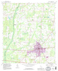 1994 Chipley1995 Print · USGSNorthwest Florida's tri-county borderlands come into focus in the mid-nineties, centered on the growing seat of Chipley. Researchers can trace local landmarks like Glenwood Cem, the old Drive-in Theater, and small settlements such as Richter Crossroads.
 - 1994 Map of Izagora, 1998 Print
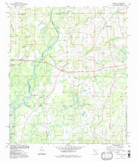 1994 Izagora1998 Print · USGSThe Alabama-Florida state line comes alive in the late twentieth century as it crosses the winding Choctawhatchee River. Genealogists and local historians can trace legacy sites like Curry Ferry, Smith Crossroads, and the Cedar Grove Ch.
 - 1994 Map of Ponce De Leon, 1998 Print
 1994 Ponce De Leon1998 Print · USGSWalton County in the mid-1990s remained a landscape of spring-fed waters and rural crossroads before the rapid growth of the modern era. Genealogists and local historians can trace family landmarks like Knox Hill, Douglass Crossroads, and Beech Grove Ch.
 - 1994 Map of Graceville, 1998 Print
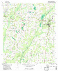 1994 Graceville1998 Print · USGSGraceville and the Alabama state line are captured in the late twentieth century, showing a rural landscape defined by rail crossings and cypress bays. Genealogists can locate family landmarks like Murphy Hill, Collins Mill, and country churches such as Damascus Ch.
 - 1994 Map of Wausau, 1998 Print
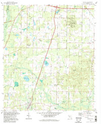 1994 Wausau1998 Print · USGSWashington County during the late twentieth century reveals a landscape of sinkholes and rural homesteads. Genealogists and local historians can trace legacy sites like Washington Ch, Everett Cem, and the high ground of Falling Waters Hill.
End of results
Showing maps 1-5 of 5
Top cities of Holmes County
- Bonifay historical maps
- Ponce de Leon historical maps
- Esto historical maps
- Westville historical maps
- Noma historical maps
Frequently asked questions
- What are the different types of historical maps available for Holmes County?
- What is the oldest map of Holmes County?
- Where can I purchase historical maps of Holmes County for my home or office?
- Where can I download high-res historical maps of Holmes County?
- Are there historical topographic maps available for Holmes County?
- Is there historical aerial imagery available for Holmes County?
- Where are historical maps of Holmes County sourced from?