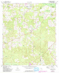
1987 Map of Darlington
USGS Topo · Published 1993About this map
The boundary between Florida and Alabama defines the northern edge of this landscape, where the Pea River and Little River meet at the tri-county junction of Geneva, Walton, and Holmes. Small rural communities like Limestone and Darlington serve as focal points for a region defined by family-named landmarks and water bodies. The settlement pattern here is deeply tied to the land, with numerous bay features such as Dukes Bay and Porter Bay dotting the terrain between larger wetlands like Gum Creek Bay.
Find a feature on this map
40 named features on this map. Tap any name to fly to it.
Don’t see what you’re looking for? This feature index may not catch every label — zoom into the map to look around manually.
Map Details
Editions of this 1987 Darlington Map
This is the sole edition of this map. No revisions or reprints were ever made.
Other maps of this area

1942 · Enterprise
USGS Topo · 1:125,000

1949 · Glendale
USGS Topo · 1:62,500

1949 · Hobbs Crossroads
USGS Topo · 1:24,000

1950 · Hobbs Cross Roads
USGS Topo · 1:24,000

1950 · Prosperity
USGS Topo · 1:24,000

1951 · Glendale
USGS Topo · 1:62,500

1953 · Andalusia
USGS Topo · 1:250,000

1953 · Dothan
USGS Topo · 1:250,000

1954 · Dothan
USGS Topo · 1:250,000

1954 · Tallahassee
USGS Topo · 1:250,000