1900s (20th Century) Maps of Westville, Florida
Explore 11 historic maps of Westville from the 1900s (20th Century). These maps offer a rare glimpse into what life looked like during the 1900s — showing old roads, neighborhoods, homes, and landmarks that have changed or disappeared over time.
Whether you're researching your family's past, planning a metal detecting trip, or studying how Westville's landscape evolved across the 1900s, these high-resolution maps are a powerful tool for exploring the history of this region.
- Focus on a specific era: All maps on this page are from the 1900s, giving you a focused view of this time period.
- See what’s changed: Compare century-old streets, trails, and buildings to today's modern landscape using overlays and satellite layers.
- Research with precision: Use these maps for genealogy, historical research, land use analysis, or educational projects.
- View, download, or print: Maps are fully viewable online in high resolution, and can be downloaded or printed for your own records.
Start exploring Westville's history through authentic maps from the 1900s. This is your window into the past.
Westville, FL maps
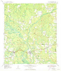
(11)- 1949 Map of Hinsons Cross Roads, 1972 Print
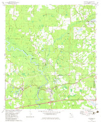
 1949 Hinsons Cross Roads1972 Print · USGSFlorida Panhandle life in the late 1940s centers on the river bends and rural intersections where the boundaries of Washington, Holmes, and Walton counties meet. Researchers can trace family ties through community landmarks like Hinsons Cross Roads, Davis Sch, and New Bethany Ch.
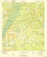
 - 1949 Map of Caryville, 1973 Print
 1949 Caryville1973 Print · USGSThe Choctawhatchee River floodplain in the late 1940s reveals a landscape of winding sloughs and rail-side settlements. Genealogists can trace family names at Westville Cem and Dyson Cem or locate rural schools like New Prospect Sch and Union Sch.
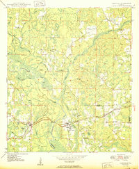
 - 1950 Map of Hinsons Cross Roads
 1950 Hinsons Cross Roads1950 Print · USGSFlorida's Panhandle is documented here at the midpoint of the century, showing the rural intersections of Washington, Holmes, and Walton counties. Genealogists can trace local landmarks like St Matthews Ch, Clarkston Cem, and the community at Hinsons Cross Roads.
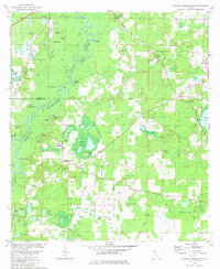
 - 1950 Map of Caryville
 1950 Caryville1950 Print · USGSThe Choctawhatchee River lowlands come to life in this 1950s survey of the Holmes and Washington border. Genealogists can locate family landmarks like Blackman Cem, Forehand Cem, and schools in Gritney or Winterville.
 - 1954 Map of Tallahassee, 1967 Print
 1954 Tallahassee1967 Print · USGSThe Florida Panhandle and South Georgia are captured here during a period of mid-century growth and military expansion. Researchers can trace the development of Panama City, the footprint of Tyndall Air Force Base, and the rail lines of the Atlantic Coast Line.4 unique versions available
 - 1959 Map of Tallahassee
 1959 Tallahassee1959 Print · USGSFlorida's Panhandle and the Big Bend region appear here in the mid-fifties, showing a landscape defined by its great river systems and developing coast. Trace the early layout of Panama City, the expansive Apalachicola National Forest, and the coastal St Marks Lighthouse.
 - 1960 Map of Tallahassee
 1960 Tallahassee1960 Print · USGSThe Florida Panhandle and southern Georgia are captured here in the mid-twentieth century, showing a region defined by its rivers and military installations. Genealogists and historians can trace the growth of Tallahassee or locate coastal landmarks like the St Marks Lighthouse and Tyndall Air Force Base.
 - 1979 Map of Marianna, 1980 Print
 1979 Marianna1980 Print · USGSFlorida's northern panhandle and the neighboring Alabama-Georgia borderlands are captured here in the late seventies. Genealogists and local historians can trace family roots through settlements like Graceville and Cottondale or follow the historic Louisville and Nashville rail lines.2 unique versions available
 - 1982 Map of Hinsons Crossroads
 1982 Hinsons Crossroads1982 Print · USGSThe Florida Panhandle's riverine landscape is meticulously documented here during the early eighties, centered on the Choctawhatchee River. Genealogists can locate family-named landmarks like Cooey Field and rural churches including New Bethany Ch and St Matthews Cem Ch.
 - 1982 Map of Caryville, 1983 Print
 1982 Caryville1983 Print · USGSCaryville and the surrounding Panhandle wetlands are captured here in the early eighties at the junction of the river and rail. Researchers can trace family roots at Westville Cem or locate rural centers like Gritney and Shady Grove Ch.
 - 1988 Map of Tallahassee
 1988 Tallahassee1988 Print · USGSThe Florida Panhandle and South Georgia are captured here in the late eighties, showing the expansion of the regional highway network and coastal growth. Genealogists and historians can trace rail lines like the Seaboard System Railroad or locate family roots in Blountstown, Graceville, or Crawfordville.2 unique versions available
End of results
Showing maps 1-11 of 11
Top cities near Westville
- Bonifay historical maps
- Vernon historical maps
- Ponce de Leon historical maps
- Esto historical maps
- Caryville historical maps
- Noma historical maps
Frequently asked questions
- What are the different types of historical maps available for Westville?
- What is the oldest map of Westville?
- Where can I purchase historical maps of Westville for my home or office?
- Where can I download high-res historical maps of Westville?
- Are there historical topographic maps available for Westville?
- Is there historical aerial imagery available for Westville?
- Where are historical maps of Westville sourced from?