1950s Maps of Marianna, Florida
Explore 5 historic maps of Marianna from the 1950s. These maps offer a rare glimpse into what life looked like during the 1950s — showing old roads, neighborhoods, homes, and landmarks that have changed or disappeared over time.
Whether you're researching your family's past, planning a metal detecting trip, or studying how Marianna's landscape evolved across the 1950s, these high-resolution maps are a powerful tool for exploring the history of this region.
- Focus on a specific era: All maps on this page are from the 1950s, giving you a focused view of this time period.
- See what’s changed: Compare century-old streets, trails, and buildings to today's modern landscape using overlays and satellite layers.
- Research with precision: Use these maps for genealogy, historical research, land use analysis, or educational projects.
- View, download, or print: Maps are fully viewable online in high resolution, and can be downloaded or printed for your own records.
Start exploring Marianna's history through authentic maps from the 1950s. This is your window into the past.
Marianna, FL maps
(5)- 1952 Map of Kynesville, 1953 Print
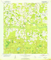 1952 Kynesville1953 Print · USGSJackson County in the early fifties is captured here as a landscape of rural churches and karst features. Genealogists and historians can trace family locations near Kynesville, the Cherokee Sch, and various landmarks like Cave Spring or Victory Cem.
 - 1952 Map of Cottondale East, 1953 Print
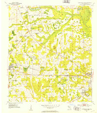 1952 Cottondale East1953 Print · USGSJackson County in the early fifties is captured here as a network of rural schools and family-named ponds between the growing hubs of Cottondale and Marianna. Genealogists can locate several vanished landmarks, including Bethlehem Sch, Antioch Ch, and the State Industrial School For Boys.2 unique versions available
 - 1952 Map of Marianna, 1953 Print
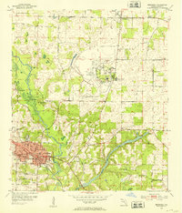 1952 Marianna1953 Print · USGSMarianna and the surrounding Jackson County countryside are captured in the early fifties, showcasing a landscape of river-fed springs and growing institutions. Genealogists can locate family landmarks like Riverside Cem and several rural schools, including Buckhorn Sch and the County Training Sch.2 unique versions available
 - 1954 Map of Tallahassee, 1967 Print
 1954 Tallahassee1967 Print · USGSThe Florida Panhandle and South Georgia are captured here during a period of mid-century growth and military expansion. Researchers can trace the development of Panama City, the footprint of Tyndall Air Force Base, and the rail lines of the Atlantic Coast Line.4 unique versions available
 - 1959 Map of Tallahassee
 1959 Tallahassee1959 Print · USGSFlorida's Panhandle and the Big Bend region appear here in the mid-fifties, showing a landscape defined by its great river systems and developing coast. Trace the early layout of Panama City, the expansive Apalachicola National Forest, and the coastal St Marks Lighthouse.
End of results
Showing maps 1-5 of 5
Top cities near Marianna
- Malone historical maps
- Cottondale historical maps
- Grand Ridge historical maps
- Greenwood historical maps
- Altha historical maps
- Alford historical maps
See more
Frequently asked questions
- What are the different types of historical maps available for Marianna?
- What is the oldest map of Marianna?
- Where can I purchase historical maps of Marianna for my home or office?
- Where can I download high-res historical maps of Marianna?
- Are there historical topographic maps available for Marianna?
- Is there historical aerial imagery available for Marianna?
- Where are historical maps of Marianna sourced from?