1900s (20th Century) Maps of Minneola, Florida
Explore 8 historic maps of Minneola from the 1900s (20th Century). These maps offer a rare glimpse into what life looked like during the 1900s — showing old roads, neighborhoods, homes, and landmarks that have changed or disappeared over time.
Whether you're researching your family's past, planning a metal detecting trip, or studying how Minneola's landscape evolved across the 1900s, these high-resolution maps are a powerful tool for exploring the history of this region.
- Focus on a specific era: All maps on this page are from the 1900s, giving you a focused view of this time period.
- See what’s changed: Compare century-old streets, trails, and buildings to today's modern landscape using overlays and satellite layers.
- Research with precision: Use these maps for genealogy, historical research, land use analysis, or educational projects.
- View, download, or print: Maps are fully viewable online in high resolution, and can be downloaded or printed for your own records.
Start exploring Minneola's history through authentic maps from the 1900s. This is your window into the past.
Minneola, FL maps
(8)- 1955 Map of Orlando, 1969 Print
 1955 Orlando1969 Print · USGSCentral Florida was entering the space age in the mid-fifties, balancing its citrus heritage with new military and aerospace frontiers. You can trace early developments at Kennedy Space Center or locate interior settlements like Eatonville and Pine Castle.3 unique versions available
 - 1957 Map of Orlando
 1957 Orlando1957 Print · USGSCovers Minneola, including Orlando, Palm Bay, and other nearby areas
 - 1958 Map of Orlando
 1958 Orlando1958 Print · USGSCentral Florida was a landscape of citrus, rail, and emerging aerospace technology during the late fifties. Researchers can trace the early footprints of Cape Canaveral and Patrick Air Force Base or locate inland citrus and rail hubs like Sanford and Lakeland.
 - 1962 Map of Orlando
 1962 Orlando1962 Print · USGSCentral Florida was transformed by aerospace and citrus at the start of the sixties. Genealogists and historians can trace old community footprints from Eau Gallie to Leesburg, alongside landmarks like McCoy AFB and the winding Econlockhatchee River.
 - 1962 Map of Clermont East, 1964 Print
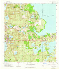 1962 Clermont East1964 Print · USGSThe Florida ridge and its sprawling lake system are shown here in the early sixties, a landscape of citrus groves and rail-side towns. Genealogists and historians can trace the paths of the Seaboard Air Line through Ferndale or locate family sites near Williams Cem and Hickory Hammock Grove.4 unique versions available
 - 1962 Map of Astatula, 1964 Print
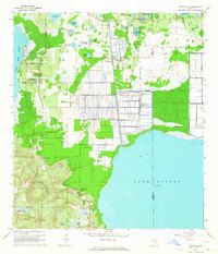 1962 Astatula1964 Print · USGSThe Lake County citrus country is captured here in the early sixties, showing the transition from agricultural groves to early residential pockets. Researchers can trace the Seaboard Air Line rail route and locate local landmarks like Sugarloaf Mountain and the Lake Apopka Lock and Dam.4 unique versions available
 - 1969 Map of Clermont West, 1971 Print
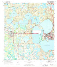 1969 Clermont West1971 Print · USGSLake County at the end of the sixties is a world of interconnected waterways and growing citrus-belt towns. Genealogists and local historians can trace family-named sites like Dukes Cem and Greenwood Cem or explore the early layout of Groveland and Mascotte.2 unique versions available
 - 1979 Map of Orlando, 1980 Print
 1979 Orlando1980 Print · USGSCentral Florida's lake country and growing urban corridors are captured here just before the decade's end. Genealogists and historians can trace the transition from citrus rail towns like Winter Garden to the suburban expansion along I-4 and Florida's Turnpike.3 unique versions available
End of results
Showing maps 1-8 of 8
Top cities near Minneola
- The Villages historical maps
- Horizon West historical maps
- Ocoee historical maps
- Winter Garden historical maps
- Clermont historical maps
- Leesburg historical maps
See more
Top neighborhoods of Minneola
- Mohawk historical maps
- Minneola Hills Apartments historical maps
- Park View at the Hills historical maps
Frequently asked questions
- What are the different types of historical maps available for Minneola?
- What is the oldest map of Minneola?
- Where can I purchase historical maps of Minneola for my home or office?
- Where can I download high-res historical maps of Minneola?
- Are there historical topographic maps available for Minneola?
- Is there historical aerial imagery available for Minneola?
- Where are historical maps of Minneola sourced from?