1990s Maps of Longboat Key, Florida
Explore 2 historic maps of Longboat Key from the 1990s. These maps offer a rare glimpse into what life looked like during the 1990s — showing old roads, neighborhoods, homes, and landmarks that have changed or disappeared over time.
Whether you're researching your family's past, planning a metal detecting trip, or studying how Longboat Key's landscape evolved across the 1990s, these high-resolution maps are a powerful tool for exploring the history of this region.
- Focus on a specific era: All maps on this page are from the 1990s, giving you a focused view of this time period.
- See what’s changed: Compare century-old streets, trails, and buildings to today's modern landscape using overlays and satellite layers.
- Research with precision: Use these maps for genealogy, historical research, land use analysis, or educational projects.
- View, download, or print: Maps are fully viewable online in high resolution, and can be downloaded or printed for your own records.
Start exploring Longboat Key's history through authentic maps from the 1990s. This is your window into the past.
Longboat Key, FL maps
(2)- 1994 Map of Bradenton, 2000 Print
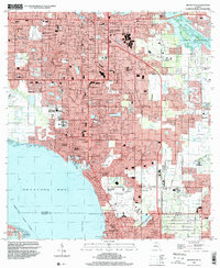 1994 Bradenton2000 Print · USGSCoastal Manatee County at the end of the twentieth century shows a landscape of rapid suburban growth between the rivers and the bay. Researchers can find long-standing community landmarks like Braden Castle, Trailer Estates, and the Ringling Museum of Art.
 - 1994 Map of Sarasota, 2000 Print
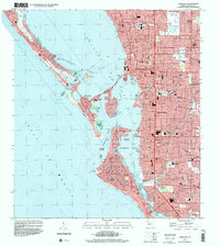 1994 Sarasota2000 Print · USGSThe Florida Gulf Coast comes alive in the mid-nineties as the shoreline development of Sarasota and its barrier islands is documented in fine detail. Researchers can trace the layout of waterfront neighborhoods from Siesta Key to Beverley Terrace and locate landmarks like the County Fairgrounds.
End of results
Showing maps 1-2 of 2
Top cities near Longboat Key
- Bradenton historical maps
- Sarasota historical maps
- Venice historical maps
- Palmetto historical maps
- Siesta Key historical maps
- Holmes Beach historical maps
See more
Top neighborhoods of Longboat Key
Frequently asked questions
- What are the different types of historical maps available for Longboat Key?
- What is the oldest map of Longboat Key?
- Where can I purchase historical maps of Longboat Key for my home or office?
- Where can I download high-res historical maps of Longboat Key?
- Are there historical topographic maps available for Longboat Key?
- Is there historical aerial imagery available for Longboat Key?
- Where are historical maps of Longboat Key sourced from?