1950s Maps of Jupiter Island, Florida
Explore 7 historic maps of Jupiter Island from the 1950s. These maps offer a rare glimpse into what life looked like during the 1950s — showing old roads, neighborhoods, homes, and landmarks that have changed or disappeared over time.
Whether you're researching your family's past, planning a metal detecting trip, or studying how Jupiter Island's landscape evolved across the 1950s, these high-resolution maps are a powerful tool for exploring the history of this region.
- Focus on a specific era: All maps on this page are from the 1950s, giving you a focused view of this time period.
- See what’s changed: Compare century-old streets, trails, and buildings to today's modern landscape using overlays and satellite layers.
- Research with precision: Use these maps for genealogy, historical research, land use analysis, or educational projects.
- View, download, or print: Maps are fully viewable online in high resolution, and can be downloaded or printed for your own records.
Start exploring Jupiter Island's history through authentic maps from the 1950s. This is your window into the past.
Jupiter Island, FL maps
(7)- 1950 Map of Jupiter
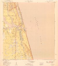 1950 Jupiter1950 Print · USGSCoastal Florida is mapped in the early postwar years as the town of Jupiter begins to expand around its famous lighthouse. Genealogists and local historians can trace landmarks like the Jupiter Cem, the US Navy Marine Base, and the old Jupiter Sch.
 - 1956 Map of West Palm Beach, 1964 Print
 1956 West Palm Beach1964 Print · USGSSouth Florida during the mid-fifties exhibits a fascinating balance between expanding coastal cities and the vast interior wetlands. Researchers can trace the development of inland settlements like Immokalee and Okeelanta or locate vanished landmarks like Chosen and Buckingham Cem.2 unique versions available
 - 1956 Map of Fort Pierce, 1965 Print
 1956 Fort Pierce1965 Print · USGSCentral and coastal Florida appear here during a period of rapid post-war growth and industrial expansion. Researchers can trace the mid-century rail-to-highway transition along the Sunshine State Parkway or locate old settlements like Ankona, Walton, and Indrio.4 unique versions available
 - 1957 Map of West Palm Beach
 1957 West Palm Beach1957 Print · USGSSouthern Florida in the mid-fifties reveals a landscape defined by massive drainage canals and the early expansion of the Gold Coast. Genealogists and historians can trace industrial outposts like the Sugar plant and Everglades Labor Center, or locate the Jupiter Auxiliary Air Force Base.
 - 1958 Map of Fort Pierce
 1958 Fort Pierce1958 Print · USGSCentral and South Florida are captured here in the late fifties as the citrus and ranching interior met the modern highway era. Researchers can trace the early path of the Sunshine State Parkway and locate established rail depots in Sebring, Okeechobee, and Arcadia.
 - 1958 Map of West Palm Beach
 1958 West Palm Beach1958 Print · USGSSouth Florida in the late fifties was a land of transition between massive agricultural works and rapid coastal growth. Genealogists and historians can trace old canal networks, early rail lines like the Florida East Coast, and landmarks like the Moore Haven Lock or Jupiter Auxiliary Air Force Base.2 unique versions available
 - 1959 Map of Fort Pierce
 1959 Fort Pierce1959 Print · USGSCentral Florida and the Treasure Coast are shown here in the late fifties, during a period of steady citrus and coastal growth. Trace the historic routes of the Florida East Coast Ry or locate the boundaries of the Seminole Indian Reservation and Highlands Hammock State Park.3 unique versions available
End of results
Showing maps 1-7 of 7
Top cities near Jupiter Island
- Port Saint Lucie historical maps
- West Palm Beach historical maps
- Palm Beach Gardens historical maps
- Jupiter historical maps
- Stuart historical maps
- North Palm Beach historical maps
See more
Frequently asked questions
- What are the different types of historical maps available for Jupiter Island?
- What is the oldest map of Jupiter Island?
- Where can I purchase historical maps of Jupiter Island for my home or office?
- Where can I download high-res historical maps of Jupiter Island?
- Are there historical topographic maps available for Jupiter Island?
- Is there historical aerial imagery available for Jupiter Island?
- Where are historical maps of Jupiter Island sourced from?