Old Maps of Wynnehaven Beach, Florida for Academic Research
Study the evolution of Wynnehaven Beach with 15 high-resolution historic maps. Whether you're teaching, researching, or modeling changes in land use, these maps provide essential visual documentation of urban, environmental, and geographic change.
- Analyze long-term change: Track patterns in development, transportation, and natural features.
- Ideal for environmental or urban studies: Support academic projects with primary historical map data.
- Use in the classroom or lab: Educators and researchers rely on these maps to bring historical context to life.
These maps are a powerful tool for teaching, research, and visualizing how Wynnehaven Beach has changed over the decades.
Wynnehaven Beach, FL maps
(15)- 1921 Map of Holley
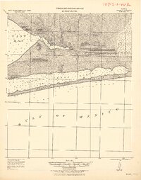 1921 Holley1921 Print · USGSThe Florida panhandle coastline near Holley appears here as it was in the early 1920s, a landscape of quiet sounds and barrier islands. Genealogists and researchers can trace old settlements and coastal landmarks like Harper, Hiawatha, and Manatee Pt.
 - 1936 Map of Holley
 1936 Holley1936 Print · USGSThe Florida Panhandle coast near Santa Rosa County appears here during the mid-1930s, showing a quiet landscape of timber and wetlands. Genealogists and historians can trace early settlements at Holley and Navarre or locate landmarks like the Indian Head Fire Tower and Holley Ch.3 unique versions available
 - 1938 Map of Holley
 1938 Holley1938 Print · USGSThe Florida Panhandle's coastline and interior forests appear here in the mid-thirties, before modern development transformed the shore. Researchers can trace early settlements at Holley and Navarre or locate landmarks like the East Bay Ch and East Bay Ranger Station.3 unique versions available
 - 1957 Map of Pensacola, 1967 Print
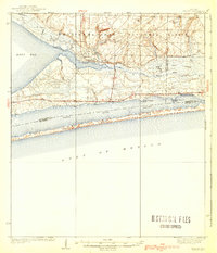
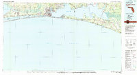
 1957 Pensacola1967 Print · USGSThe Florida Panhandle and Alabama coast are seen here at the height of the Cold War, showcasing a unique mix of military aviation and emerging beach tourism. Genealogists and local historians can trace legacy sites like Old Corry Field, the lumber town of Bagdad, and the coastal reaches of Santa Rosa Island.3 unique versions available
 - 1959 Map of Pensacola
 1959 Pensacola1959 Print · USGSThe Florida Panhandle and Alabama coast come alive in this late fifties survey of military aviation and maritime life. Genealogists can trace family roots in Bagdad, Loxley, and Milton while mapping the rails of the Louisville and Nashville.
 - 1960 Map of Pensacola
 1960 Pensacola1960 Print · USGSThe Florida Panhandle and Alabama's eastern shore are shown during a period of rapid military and coastal growth. Genealogists and historians can trace the mid-century footprints of Warrington, the Pensacola NAS (Chevalier), and the Blackwater River timber lands.
 - 1970 Map of Navarre, 1972 Print
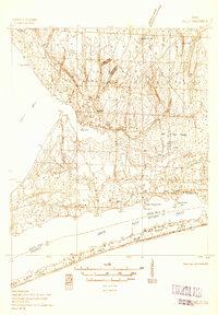
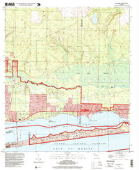
 1970 Navarre1972 Print · USGSThe Florida Panhandle coast near the turn of the 1970s shows a landscape defined by military range lands and emerging beach communities. Researchers can trace the mid-century layout of Navarre, Wynnehaven Beach, and the installations within Eglin Air Force Base.3 unique versions available
 - 1978 Map of Fort Walton Beach, 1980 Print
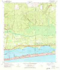
 1978 Fort Walton Beach1980 Print · USGSThe Florida Panhandle in the late seventies reveals a landscape defined by the growth of Eglin Air Force Base and the shoreline of Choctawhatchee Bay. Genealogists and historians can trace the early footprints of Fort Walton Beach, Destin, and remote coastal outposts like Point Washington.2 unique versions available
 - 1994 Map of Navarre, 1999 Print
 1994 Navarre1999 Print · USGSSanta Rosa County coastal life and military infrastructure intersect in the mid-1990s as the local community grows between the bay and the Gulf. Genealogists and historians can trace the developments of Navarre and Wynnehaven Beach alongside landmarks like the Landing Strip and Lookout Tower.
 - 2012 Map of Navarre, 2012 Print
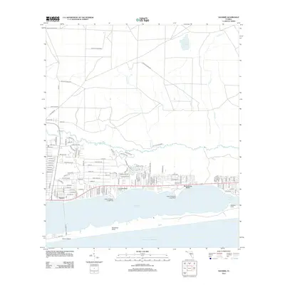 2012 Navarre2012 Print · USGSCovers Wynnehaven Beach, including Navarre, Okaloosa County, and other nearby areas
 - 2015 Map of Navarre, 2015 Print
 2015 Navarre2015 Print · USGSCovers Wynnehaven Beach, including Navarre, Okaloosa County, and other nearby areas
 - 2018 Map of Navarre, 2018 Print
 2018 Navarre2018 Print · USGSCovers Wynnehaven Beach, including Navarre, Okaloosa County, and other nearby areas
 - 2021 Map of Navarre, 2021 Print
 2021 Navarre2021 Print · USGSCovers Wynnehaven Beach, including Navarre, Okaloosa County, and other nearby areas
 - 2024 Map of Navarre, 2024 Print
 2024 Navarre2024 Print · USGSCovers Wynnehaven Beach, including Navarre, Okaloosa County, and other nearby areas
 - 2025 Map of Navarre, 2025 Print
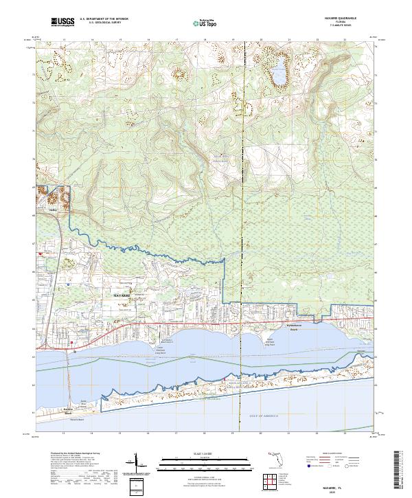 2025 Navarre2025 Print · USGSNavarre and the Santa Rosa Sound shoreline are depicted here in the mid-2020s, showing the intersection of coastal growth and vast military lands. Researchers can trace local development near Wynnehaven Beach, the Fort Walton Beach Airport, and the protected Gulf Islands National Seashore.
End of results
Showing maps 1-15 of 15
Top cities near Wynnehaven Beach
- Navarre historical maps
- Fort Walton Beach historical maps
- Mary Esther historical maps
- Shalimar historical maps
- Cinco Bayou historical maps
Frequently asked questions
- What are the different types of historical maps available for Wynnehaven Beach?
- What is the oldest map of Wynnehaven Beach?
- Where can I purchase historical maps of Wynnehaven Beach for my home or office?
- Where can I download high-res historical maps of Wynnehaven Beach?
- Are there historical topographic maps available for Wynnehaven Beach?
- Is there historical aerial imagery available for Wynnehaven Beach?
- Where are historical maps of Wynnehaven Beach sourced from?