1970s Maps of Okeechobee County, Florida
Explore 4 historic maps of Okeechobee County from the 1970s. These maps offer a rare glimpse into what life looked like during the 1970s — showing old roads, neighborhoods, homes, and landmarks that have changed or disappeared over time.
Whether you're researching your family's past, planning a metal detecting trip, or studying how Okeechobee County's landscape evolved across the 1970s, these high-resolution maps are a powerful tool for exploring the history of this region.
- Focus on a specific era: All maps on this page are from the 1970s, giving you a focused view of this time period.
- See what’s changed: Compare century-old streets, trails, and buildings to today's modern landscape using overlays and satellite layers.
- Research with precision: Use these maps for genealogy, historical research, land use analysis, or educational projects.
- View, download, or print: Maps are fully viewable online in high resolution, and can be downloaded or printed for your own records.
Start exploring Okeechobee County's history through authentic maps from the 1970s. This is your window into the past.
Okeechobee County, FL maps
(4)- 1971 Map of Okeechobee SE, 1976 Print
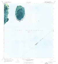 1971 Okeechobee SE1976 Print · USGSThe open waters of the lake take center stage in the early 1970s, offering a detailed aerial view of submerged geography. Trace the outlines of North Lake Shoal and follow the near-shore Boat Trail as it was recorded decades ago.
 - 1971 Map of Cochrans Pass, 1976 Print
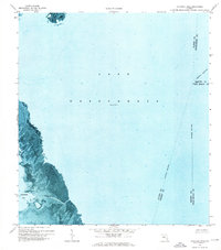 1971 Cochrans Pass1976 Print · USGSLake Okeechobee and its western marshlands are captured in high detail during the early 1970s. Trace the seasonal water patterns and historic navigation routes like Cochrans Pass, the Airboat Tr, and Moonshine Bay.
 - 1978 Map of Arcadia, 1980 Print
 1978 Arcadia1980 Print · USGSDeSoto and Highlands counties are shown here in the late seventies, a landscape defined by the Peace River and extensive citrus groves. Genealogists and researchers can trace the SEABOARD COAST LINE railroad through old settlements like Nocatee, Zolfo Springs, and Fort Ogden.
 - 1978 Map of Bartow, 1980 Print
 1978 Bartow1980 Print · USGSCentral Florida during the late seventies was a landscape of industrial phosphate mines and expansive lake systems. Trace the legacy of the Seaboard Coast Line as it connects Fort Meade, Wauchula, and the massive Avon Park Bombing Range.2 unique versions available
End of results
Showing maps 1-4 of 4
Top cities of Okeechobee County
Frequently asked questions
- What are the different types of historical maps available for Okeechobee County?
- What is the oldest map of Okeechobee County?
- Where can I purchase historical maps of Okeechobee County for my home or office?
- Where can I download high-res historical maps of Okeechobee County?
- Are there historical topographic maps available for Okeechobee County?
- Is there historical aerial imagery available for Okeechobee County?
- Where are historical maps of Okeechobee County sourced from?