1940s Maps of Kings Point, Florida
Explore 2 historic maps of Kings Point from the 1940s. These maps offer a rare glimpse into what life looked like during the 1940s — showing old roads, neighborhoods, homes, and landmarks that have changed or disappeared over time.
Whether you're researching your family's past, planning a metal detecting trip, or studying how Kings Point's landscape evolved across the 1940s, these high-resolution maps are a powerful tool for exploring the history of this region.
- Focus on a specific era: All maps on this page are from the 1940s, giving you a focused view of this time period.
- See what’s changed: Compare century-old streets, trails, and buildings to today's modern landscape using overlays and satellite layers.
- Research with precision: Use these maps for genealogy, historical research, land use analysis, or educational projects.
- View, download, or print: Maps are fully viewable online in high resolution, and can be downloaded or printed for your own records.
Start exploring Kings Point's history through authentic maps from the 1940s. This is your window into the past.
Kings Point, FL maps
(2)- 1947 Map of Delmar Farms, 1961 Print
 1947 Delmar Farms1961 Print · USGSPalm Beach County’s agricultural interior and wetlands are captured in the late 1940s as infrastructure began to redefine the landscape. Researchers can trace the early layout of Delmar Farms, the settlement at Dewitt, and the path of the Sunshine State Parkway.
 - 1949 Map of Delmar Farms
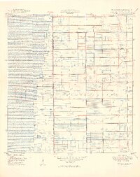 1949 Delmar Farms1949 Print · USGSPalm Beach County's agricultural frontier is captured here in the late 1940s, showcasing the massive drainage projects at the edge of the Everglades. Researchers can trace the early layout of Delmar Farms, the small settlement of Dewitt, and the path of Atlantic Avenue.2 unique versions available
End of results
Showing maps 1-2 of 2
Top cities near Kings Point
- Coral Springs historical maps
- West Palm Beach historical maps
- Pompano Beach historical maps
- Boca Raton historical maps
- Deerfield Beach historical maps
- Boynton Beach historical maps
See more
Frequently asked questions
- What are the different types of historical maps available for Kings Point?
- What is the oldest map of Kings Point?
- Where can I purchase historical maps of Kings Point for my home or office?
- Where can I download high-res historical maps of Kings Point?
- Are there historical topographic maps available for Kings Point?
- Is there historical aerial imagery available for Kings Point?
- Where are historical maps of Kings Point sourced from?