1940s Maps of Ocean Ridge, Florida
Explore 2 historic maps of Ocean Ridge from the 1940s. These maps offer a rare glimpse into what life looked like during the 1940s — showing old roads, neighborhoods, homes, and landmarks that have changed or disappeared over time.
Whether you're researching your family's past, planning a metal detecting trip, or studying how Ocean Ridge's landscape evolved across the 1940s, these high-resolution maps are a powerful tool for exploring the history of this region.
- Focus on a specific era: All maps on this page are from the 1940s, giving you a focused view of this time period.
- See what’s changed: Compare century-old streets, trails, and buildings to today's modern landscape using overlays and satellite layers.
- Research with precision: Use these maps for genealogy, historical research, land use analysis, or educational projects.
- View, download, or print: Maps are fully viewable online in high resolution, and can be downloaded or printed for your own records.
Start exploring Ocean Ridge's history through authentic maps from the 1940s. This is your window into the past.
Ocean Ridge, FL maps
(2)- 1945 Map of Lake Worth, 1962 Print
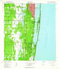 1945 Lake Worth1962 Print · USGSThe Florida coast near Lake Worth is documented here just after the war, showing the expansion of rail and water infrastructure. Genealogists and local historians can trace early residential footprints in Lantana, Boynton Beach, and across Hypoluxo Island.4 unique versions available
 - 1949 Map of Lake Worth
 1949 Lake Worth1949 Print · USGSPalm Beach County’s shoreline and inland rail corridors are documented in the late 1940s during a pivotal era of South Florida development. Genealogists and historians can trace the early footprints of Lantana and Boynton Beach, or locate landmarks like Hypoluxo Island and the Palm Beach County Airport.
End of results
Showing maps 1-2 of 2
Top cities near Ocean Ridge
- West Palm Beach historical maps
- Boca Raton historical maps
- Deerfield Beach historical maps
- Boynton Beach historical maps
- Delray Beach historical maps
- Wellington historical maps
See more
Frequently asked questions
- What are the different types of historical maps available for Ocean Ridge?
- What is the oldest map of Ocean Ridge?
- Where can I purchase historical maps of Ocean Ridge for my home or office?
- Where can I download high-res historical maps of Ocean Ridge?
- Are there historical topographic maps available for Ocean Ridge?
- Is there historical aerial imagery available for Ocean Ridge?
- Where are historical maps of Ocean Ridge sourced from?