1940s Maps of Placido Bayou, Saint Petersburg
Explore 4 historic maps of Placido Bayou from the 1940s. These maps offer a rare glimpse into what life looked like during the 1940s — showing old roads, neighborhoods, homes, and landmarks that have changed or disappeared over time.
Whether you're researching your family's past, planning a metal detecting trip, or studying how Placido Bayou's landscape evolved across the 1940s, these high-resolution maps are a powerful tool for exploring the history of this region.
- Focus on a specific era: All maps on this page are from the 1940s, giving you a focused view of this time period.
- See what’s changed: Compare century-old streets, trails, and buildings to today's modern landscape using overlays and satellite layers.
- Research with precision: Use these maps for genealogy, historical research, land use analysis, or educational projects.
- View, download, or print: Maps are fully viewable online in high resolution, and can be downloaded or printed for your own records.
Start exploring Placido Bayou's history through authentic maps from the 1940s. This is your window into the past.
Placido Bayou, Saint Petersburg maps
(4)- 1943 Map of St Petersburg
 1943 St Petersburg1943 Print · USGSThe Pinellas peninsula thrived during the mid-forties as a center for aviation and maritime training. Researchers can trace early urban development and transit lines like Tyrone Blvd, or locate local landmarks including Albert Whitted Airport and Royal Palm Cem.
 - 1943 Map of Port Tampa
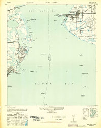
 1943 Port Tampa1943 Print · USGSThe Tampa Bay shoreline during World War II reveals a mix of wartime military expansion and early suburban development. Genealogists and historians can trace the foundations of Snell Isle, the industrial works at Port Tampa, and the early layout of MacDill Field.
 - 1947 Map of Port Tampa
 1947 Port Tampa1947 Print · USGSThe Florida coast just after the war shows the expansion of military and maritime infrastructure along Old Tampa Bay. Genealogists and historians can trace the early layouts of Shore Acres and Snell Isle or locate landmarks like the Port Tampa Dock.3 unique versions available
 - 1947 Map of St Petersburg
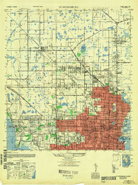 1947 St Petersburg1947 Print · USGSThe Pinellas peninsula emerged into a new era of growth following the war, as urban limits expanded toward Pinellas Park and Gulfport. Local historians can trace early neighborhood schools like Euclid School and landmark institutions such as Albert Whitted Airport or the Dog Track.
End of results
Showing maps 1-4 of 4
Frequently asked questions
- What are the different types of historical maps available for Placido Bayou?
- What is the oldest map of Placido Bayou?
- Where can I purchase historical maps of Placido Bayou for my home or office?
- Where can I download high-res historical maps of Placido Bayou?
- Are there historical topographic maps available for Placido Bayou?
- Is there historical aerial imagery available for Placido Bayou?
- Where are historical maps of Placido Bayou sourced from?