1900s (20th Century) Maps of Georges Lake, Florida
Explore 8 historic maps of Georges Lake from the 1900s (20th Century). These maps offer a rare glimpse into what life looked like during the 1900s — showing old roads, neighborhoods, homes, and landmarks that have changed or disappeared over time.
Whether you're researching your family's past, planning a metal detecting trip, or studying how Georges Lake's landscape evolved across the 1900s, these high-resolution maps are a powerful tool for exploring the history of this region.
- Focus on a specific era: All maps on this page are from the 1900s, giving you a focused view of this time period.
- See what’s changed: Compare century-old streets, trails, and buildings to today's modern landscape using overlays and satellite layers.
- Research with precision: Use these maps for genealogy, historical research, land use analysis, or educational projects.
- View, download, or print: Maps are fully viewable online in high resolution, and can be downloaded or printed for your own records.
Start exploring Georges Lake's history through authentic maps from the 1900s. This is your window into the past.
Georges Lake, FL maps
(8)- 1942 Map of Ates Creek
 1942 Ates Creek1942 Print · USGSNorthern Florida's training grounds and rural settlements come into focus during the early mobilization of the Second World War. Researchers can trace the military layout of Camp Blanding alongside the agricultural colony at Penney Farms and the springs of Gold Head Branch.
 - 1949 Map of Rice Creek, 1953 Print
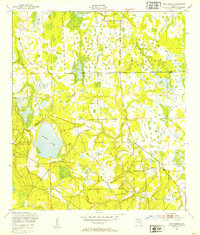 1949 Rice Creek1953 Print · USGSIn the late 1940s, the borderlands between Clay and Putnam Counties remained a dense mosaic of wetlands and winding waterways. Researchers can trace the pristine hydrology of the region through Georges Lake and the paths of Etonia Creek and Rice Creek.3 unique versions available
 - 1949 Map of Ates Creek, 1955 Print
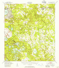 1949 Ates Creek1955 Print · USGSClay County during the post-war era shows a landscape transitioning between military readiness and civilian growth. Researchers can locate the sprawling Camp Blanding facilities, the planned community of Penney Farms, and historic sites like Beulah Cem.2 unique versions available
 - 1954 Map of Daytona Beach, 1974 Print
 1954 Daytona Beach1974 Print · USGSNortheast Florida is captured in the mid-1950s, showing the transition from river-based commerce to coastal tourism. Researchers can trace the Florida East Coast rail lines and find historic sites like Castillo de San Marcos Nat Mon and Palatka.
 - 1958 Map of Daytona Beach
 1958 Daytona Beach1958 Print · USGSThe Florida coast and St. Johns River valley are captured in the late 1950s, showing a landscape defined by citrus-belt rail towns and Atlantic shorelines. Genealogists can trace family roots through riverside settlements like Palatka and Welaka or coastal hubs like Daytona Beach.2 unique versions available
 - 1964 Map of Daytona Beach
 1964 Daytona Beach1964 Print · USGSCoastal Florida in the mid-1960s shows a fascinating balance between burgeoning beach tourism and the deep interior wilderness of the Ocala National Forest. Researchers can trace the path of the Florida East Coast railway through historic settlements like St. Augustine, Marineland, and Palatka.
 - 1981 Map of Saint Augustine, 1982 Print
 1981 Saint Augustine1982 Print · USGSNortheast Florida in the early eighties shows a landscape of deep river commerce and coastal growth. Genealogists and historians can trace the inland rail network of the Seaboard Coast Line through rural Hastings or explore the military footprint of Camp Blanding.2 unique versions available
 - 1993 Map of Rice Creek
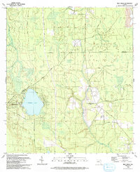 1993 Rice Creek1993 Print · USGSFlorida's wet lowlands along the Clay and Putnam county line are captured here in the early nineties, centered on the community of Harlem. Genealogists and researchers can trace family landmarks like Mt Hebron Cem, Union Grove Cem, and Providence Ch.
End of results
Showing maps 1-8 of 8
Top cities near Georges Lake
- Palatka historical maps
- Green Cove Springs historical maps
- Starke historical maps
- Interlachen historical maps
- Keystone Heights historical maps
- Hawthorne historical maps
See more
Frequently asked questions
- What are the different types of historical maps available for Georges Lake?
- What is the oldest map of Georges Lake?
- Where can I purchase historical maps of Georges Lake for my home or office?
- Where can I download high-res historical maps of Georges Lake?
- Are there historical topographic maps available for Georges Lake?
- Is there historical aerial imagery available for Georges Lake?
- Where are historical maps of Georges Lake sourced from?