1900s (20th Century) Maps of Nocatee, Florida
Explore 12 historic maps of Nocatee from the 1900s (20th Century). These maps offer a rare glimpse into what life looked like during the 1900s — showing old roads, neighborhoods, homes, and landmarks that have changed or disappeared over time.
Whether you're researching your family's past, planning a metal detecting trip, or studying how Nocatee's landscape evolved across the 1900s, these high-resolution maps are a powerful tool for exploring the history of this region.
- Focus on a specific era: All maps on this page are from the 1900s, giving you a focused view of this time period.
- See what’s changed: Compare century-old streets, trails, and buildings to today's modern landscape using overlays and satellite layers.
- Research with precision: Use these maps for genealogy, historical research, land use analysis, or educational projects.
- View, download, or print: Maps are fully viewable online in high resolution, and can be downloaded or printed for your own records.
Start exploring Nocatee's history through authentic maps from the 1900s. This is your window into the past.
Nocatee, FL maps
(12)- 1918 Map of Palm Valley
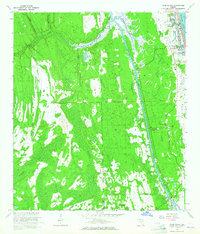
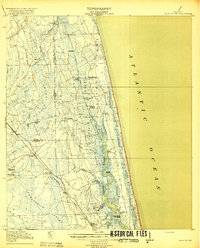 1918 Palm Valley1918 Print · USGSCoastal St. Johns County in the years before heavy development was a wilderness of swamps and vital river landings. Genealogists and researchers can trace early homesteads and rail stops like Sampson, Hilden, and the small community at Palm Valley.4 unique versions available
 - 1948 Map of Jacksonville
 1948 Jacksonville1948 Print · USGSNortheast Florida and Southeast Georgia's coastal waterways and railroad towns are captured here in the years following the war. Genealogists can trace family connections through river towns like St Marys or identify long-standing military landmarks like Jacksonville NAS.
 - 1952 Map of South Ponte Vedra Beach, 1956 Print
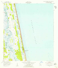 1952 South Ponte Vedra Beach1956 Print · USGSThe St. Johns County coastline is captured in the early 1950s, showing the narrow barrier strand and its transition into the vast Tolomato River marshes. Genealogists and historians can trace old river access points like Cook Landing, Spanish Landing, and the seaside Flowing Well.5 unique versions available
 - 1952 Map of Durbin, 1956 Print
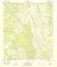 1952 Durbin1956 Print · USGSCoastal St. Johns County appears here in the early fifties, where the railroad and the Intracoastal Waterway dictate the local geography. Genealogists and historians can trace the small rail stops at Durbin and Hilden or locate the Lookout Tower and Ninemile Road.3 unique versions available
 - 1952 Map of Palm Valley, 1956 Print
 1952 Palm Valley1956 Print · USGSCoastal St. Johns County in the early fifties shows a landscape of developing beach communities and vast, untouched wetlands. Trace the early layout of Ponte Vedra Beach or explore the interior near Palm Valley Landing and the winding reaches of Durbin Swamp.2 unique versions available
 - 1957 Map of Jacksonville, 1967 Print
 1957 Jacksonville1967 Print · USGSCoastal Florida and Georgia meet in the late fifties, showcasing a landscape of naval aviation, deep-water terminals, and barrier island communities. Researchers can trace the mid-century footprints of NAS Jacksonville, find small communities like Franklintown, and locate the historic Fort Clinch State Park.3 unique versions available
 - 1959 Map of Jacksonville
 1959 Jacksonville1959 Print · USGSNortheast Florida and Southeast Georgia are seen here in the late fifties, dominated by the maritime activity of the St Johns River and the Atlantic coast. Researchers can trace the mid-century layout of Jacksonville and identify sprawling military sites like Camp Blanding Military Reservation and Kings Bay Ammunition Terminal.
 - 1960 Map of Jacksonville
 1960 Jacksonville1960 Print · USGSCoastal Florida and Georgia meet in this mid-century portrait of a region shaped by naval power and the winding St Johns River. Researchers can trace the development of military sites like Cecil Field or locate historic rural landmarks such as Jerusalem Ch and Kings Ferry.
 - 1964 Map of Palm Valley, 1965 Print
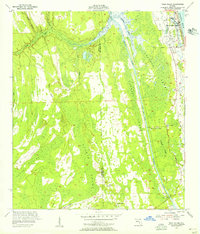
 1964 Palm Valley1965 Print · USGSPalm Valley and the northeast Florida coast are shown here in the mid-sixties, capturing the early layout of seaside communities and interior wetlands. Researchers can trace the development of Ponte Vedra and locate rural landmarks like Twentymile and Palm Valley Landing.5 unique versions available
 - 1977 Map of Jacksonville, 1983 Print
 1977 Jacksonville1983 Print · USGSNortheast Florida during the late seventies shows a region defined by its deep-water naval bases and burgeoning riverfront suburbs. You can trace the rail networks of the Seaboard Coast Line, locate the Kingsley Plantation, and study the sprawling grounds of Cecil Field Naval Air Station.
 - 1980 Map of Jacksonville, 1984 Print
 1980 Jacksonville1984 Print · USGSThe Jacksonville metropolitan area and the Atlantic coast are captured here during a period of significant late-century growth. Researchers can trace the massive military footprints of Cecil Field and Mayport Naval Station alongside historic communities like Mandarin and Switzerland.
 - 1988 Map of Jacksonville
 1988 Jacksonville1988 Print · USGSCoastal Florida and Georgia are captured here during the late eighties, documenting the rapid growth of the First Coast and its vital military installations. Researchers can trace the development of beach communities like Fernandina Beach and Atlantic Beach or locate family landmarks near Mickler Landing and Orange Park.
End of results
Showing maps 1-12 of 12
Top cities near Nocatee
- Jacksonville historical maps
- Fruit Cove historical maps
- Ponte Vedra Beach historical maps
- Jacksonville Beach historical maps
- Saint Augustine historical maps
- Neptune Beach historical maps
See more
Top neighborhoods of Nocatee
Frequently asked questions
- What are the different types of historical maps available for Nocatee?
- What is the oldest map of Nocatee?
- Where can I purchase historical maps of Nocatee for my home or office?
- Where can I download high-res historical maps of Nocatee?
- Are there historical topographic maps available for Nocatee?
- Is there historical aerial imagery available for Nocatee?
- Where are historical maps of Nocatee sourced from?