1930s Maps of Saint Augustine, Florida
Explore 2 historic maps of Saint Augustine from the 1930s. These maps offer a rare glimpse into what life looked like during the 1930s — showing old roads, neighborhoods, homes, and landmarks that have changed or disappeared over time.
Whether you're researching your family's past, planning a metal detecting trip, or studying how Saint Augustine's landscape evolved across the 1930s, these high-resolution maps are a powerful tool for exploring the history of this region.
- Focus on a specific era: All maps on this page are from the 1930s, giving you a focused view of this time period.
- See what’s changed: Compare century-old streets, trails, and buildings to today's modern landscape using overlays and satellite layers.
- Research with precision: Use these maps for genealogy, historical research, land use analysis, or educational projects.
- View, download, or print: Maps are fully viewable online in high resolution, and can be downloaded or printed for your own records.
Start exploring Saint Augustine's history through authentic maps from the 1930s. This is your window into the past.
Saint Augustine, FL maps
(2)- 1937 Map of Crescent Beach
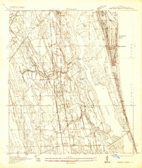 1937 Crescent Beach1937 Print · USGSCoastal St. Johns County in the late thirties shows a landscape of developing beach colonies and inland rail outposts. Researchers can locate the San Lorenzo Cem, trace the grounds of Fort Peyton, or explore industrial sites like the Turpentine Camp.
 - 1937 Map of St. Augustine
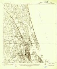 1937 St. Augustine1937 Print · USGSCoastal Florida is captured here in the late thirties, showing the historic streets of St Augustine and its surrounding marshlands. Researchers can trace the layout of Fort Marion, locate Evergreen Cemetery, and find early beach developments at Vilano Beach.
End of results
Showing maps 1-2 of 2
Top cities near Saint Augustine
- Jacksonville historical maps
- Saint Augustine Beach historical maps
- Saint Augustine South historical maps
- Saint Augustine Shores historical maps
- Hastings historical maps
- Marineland historical maps
Top neighborhoods of Saint Augustine
- Lincolnville historical maps
- Anastasia historical maps
- West Augustine historical maps
- Uptown historical maps
- Madeira at Saint Augustine historical maps
- Model Land Historic District historical maps
See more
Frequently asked questions
- What are the different types of historical maps available for Saint Augustine?
- What is the oldest map of Saint Augustine?
- Where can I purchase historical maps of Saint Augustine for my home or office?
- Where can I download high-res historical maps of Saint Augustine?
- Are there historical topographic maps available for Saint Augustine?
- Is there historical aerial imagery available for Saint Augustine?
- Where are historical maps of Saint Augustine sourced from?