1950s Maps of Seminole County, Florida
Explore 11 historic maps of Seminole County from the 1950s. These maps offer a rare glimpse into what life looked like during the 1950s — showing old roads, neighborhoods, homes, and landmarks that have changed or disappeared over time.
Whether you're researching your family's past, planning a metal detecting trip, or studying how Seminole County's landscape evolved across the 1950s, these high-resolution maps are a powerful tool for exploring the history of this region.
- Focus on a specific era: All maps on this page are from the 1950s, giving you a focused view of this time period.
- See what’s changed: Compare century-old streets, trails, and buildings to today's modern landscape using overlays and satellite layers.
- Research with precision: Use these maps for genealogy, historical research, land use analysis, or educational projects.
- View, download, or print: Maps are fully viewable online in high resolution, and can be downloaded or printed for your own records.
Start exploring Seminole County's history through authentic maps from the 1950s. This is your window into the past.
Seminole County, FL maps
(11)- 1950 Map of Aurantia, 1952 Print
 1950 Aurantia1952 Print · USGSBrevard County was a landscape of Spanish land grants and sprawling wetlands at the mid-century point. Researchers can trace the Florida East Coast rail line as it passes through Aurantia, and locate landmarks like Southmere and the Brevard County Game Refuge.5 unique versions available
 - 1953 Map of Geneva, 1955 Print
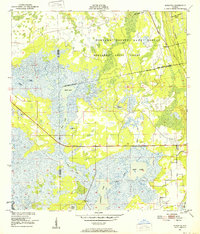
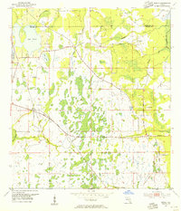
 1953 Geneva1955 Print · USGSEastern Seminole County is shown in the early 1950s as a landscape of vast river marshes and small inland settlements. Researchers can locate prehistoric sites like Palmer-Taylor Mound or trace family roots near Geneva and the Chuluota Cem.5 unique versions available
 - 1953 Map of Titusville SW, 1955 Print
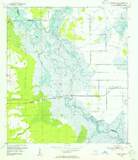 1953 Titusville SW1955 Print · USGSThe Upper St. Johns River basin is captured here in the early 1950s, showing the intricate wetlands before modern drainage projects. Researchers can locate ancient landmarks like Orange Mound or trace the early path of the Cheney Highway as it crosses the St Johns River.5 unique versions available
 - 1953 Map of Oviedo SW, 1955 Print
 1953 Oviedo SW1955 Print · USGSEastern Orange County in the early fifties was a landscape of winding rivers and scattered lakefront settlements. Genealogists and local historians can trace family-named sites like Rouse Cem, Lockwood Ch, and the crossroads at Bithlo.4 unique versions available
 - 1953 Map of Bithlo, 1955 Print
 1953 Bithlo1955 Print · USGSEast of Orlando in the early 1950s, this area remained a landscape of vast wetlands and small rural outposts. Genealogists and local historians can trace the foundations of Christmas and Bithlo, finding the Christmas Cem and an Old Railroad Grade.5 unique versions available
 - 1955 Map of Orlando, 1969 Print
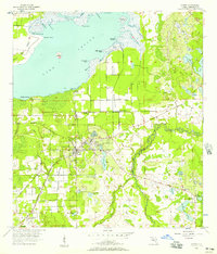
 1955 Orlando1969 Print · USGSCentral Florida was entering the space age in the mid-fifties, balancing its citrus heritage with new military and aerospace frontiers. You can trace early developments at Kennedy Space Center or locate interior settlements like Eatonville and Pine Castle.3 unique versions available
 - 1956 Map of Oviedo, 1957 Print
 1956 Oviedo1957 Print · USGSCentral Florida's citrus and rail corridor is captured here in the mid-fifties as Oviedo thrived at the intersection of two major rail lines. Researchers can trace family sites near Slavia Cem or locate old community hubs like Jamestown and Chuluota.5 unique versions available
 - 1956 Map of Orlando East, 1957 Print
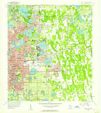 1956 Orlando East1957 Print · USGSCentral Florida underwent rapid suburbanization in the mid-fifties as military and residential hubs expanded around the lakes. Trace early neighborhoods and schools like Rollins College, Orlando Air Force Base, and Azalea Park.4 unique versions available
 - 1957 Map of Orlando
 1957 Orlando1957 Print · USGSCovers Seminole County, including Orlando, Palm Bay, and other nearby areas
 - 1958 Map of Orlando
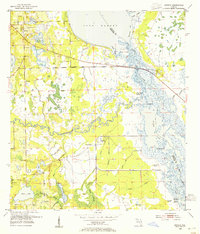
 1958 Orlando1958 Print · USGSCentral Florida was a landscape of citrus, rail, and emerging aerospace technology during the late fifties. Researchers can trace the early footprints of Cape Canaveral and Patrick Air Force Base or locate inland citrus and rail hubs like Sanford and Lakeland.
 - 1959 Map of Forest City, 1961 Print
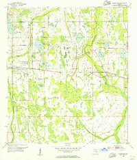
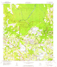 1959 Forest City1961 Print · USGSThe northern Orlando suburbs were a landscape of citrus groves and spring-fed lakes during the late fifties. Genealogists and historians can locate legacy sites like the Altamonte Springs Sch, Mt Tabor Ch, and the Highland Memory Garden.5 unique versions available
End of results
Showing maps 1-11 of 11
Top cities of Seminole County
- Sanford historical maps
- Oviedo historical maps
- Altamonte Springs historical maps
- Winter Springs historical maps
- Casselberry historical maps
- Lake Mary historical maps
See more
Frequently asked questions
- What are the different types of historical maps available for Seminole County?
- What is the oldest map of Seminole County?
- Where can I purchase historical maps of Seminole County for my home or office?
- Where can I download high-res historical maps of Seminole County?
- Are there historical topographic maps available for Seminole County?
- Is there historical aerial imagery available for Seminole County?
- Where are historical maps of Seminole County sourced from?