1940s Maps of Surf, Florida
Explore 3 historic maps of Surf from the 1940s. These maps offer a rare glimpse into what life looked like during the 1940s — showing old roads, neighborhoods, homes, and landmarks that have changed or disappeared over time.
Whether you're researching your family's past, planning a metal detecting trip, or studying how Surf's landscape evolved across the 1940s, these high-resolution maps are a powerful tool for exploring the history of this region.
- Focus on a specific era: All maps on this page are from the 1940s, giving you a focused view of this time period.
- See what’s changed: Compare century-old streets, trails, and buildings to today's modern landscape using overlays and satellite layers.
- Research with precision: Use these maps for genealogy, historical research, land use analysis, or educational projects.
- View, download, or print: Maps are fully viewable online in high resolution, and can be downloaded or printed for your own records.
Start exploring Surf's history through authentic maps from the 1940s. This is your window into the past.
Surf, FL maps
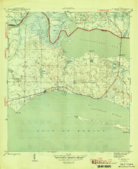
(3)- 1943 Map of St. Teresa Beach, 1969 Print
 1943 St. Teresa Beach1969 Print · USGSThe Florida Panhandle coastline during the early 1940s shows a landscape of tidal rivers and quiet shorelines before modern expansion. Genealogists and historians can trace the early layout of St Teresa Beach and the wilderness boundaries of the St Marks National Wildlife Refuge.
 - 1945 Map of St Teresa
 1945 St Teresa1945 Print · USGSThe Florida Panhandle coast near St Teresa is captured here during the mid-forties, showing a landscape of tidal bays and protected harbors. Local historians can trace the early roads and shoreline landmarks like Alligator Harbor, Mashes Island, and Shell Hammock.3 unique versions available
 - 1949 Map of Apalachicola
 1949 Apalachicola1949 Print · USGSThe Florida Panhandle's Forgotten Coast is captured mid-century, showcasing the intricate web of swamps, sounds, and barrier islands. Genealogists and historians can trace the Apalachicola Northern rail line and locate old landmarks like Fort Gadsden or the St Joe Fire Tower.
End of results
Showing maps 1-3 of 3
Top cities near Surf
- Crawfordville historical maps
- Carrabelle historical maps
- Sopchoppy historical maps
- Saint Marks historical maps
Frequently asked questions
- What are the different types of historical maps available for Surf?
- What is the oldest map of Surf?
- Where can I purchase historical maps of Surf for my home or office?
- Where can I download high-res historical maps of Surf?
- Are there historical topographic maps available for Surf?
- Is there historical aerial imagery available for Surf?
- Where are historical maps of Surf sourced from?