1900s (20th Century) Maps of Sandestin, Florida
Explore 9 historic maps of Sandestin from the 1900s (20th Century). These maps offer a rare glimpse into what life looked like during the 1900s — showing old roads, neighborhoods, homes, and landmarks that have changed or disappeared over time.
Whether you're researching your family's past, planning a metal detecting trip, or studying how Sandestin's landscape evolved across the 1900s, these high-resolution maps are a powerful tool for exploring the history of this region.
- Focus on a specific era: All maps on this page are from the 1900s, giving you a focused view of this time period.
- See what’s changed: Compare century-old streets, trails, and buildings to today's modern landscape using overlays and satellite layers.
- Research with precision: Use these maps for genealogy, historical research, land use analysis, or educational projects.
- View, download, or print: Maps are fully viewable online in high resolution, and can be downloaded or printed for your own records.
Start exploring Sandestin's history through authentic maps from the 1900s. This is your window into the past.
Sandestin, FL maps
(9)- 1935 Map of Villa Tasso
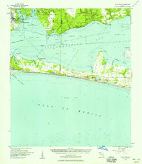
 1935 Villa Tasso1935 Print · USGSThe Florida Panhandle's coast appears here in the mid-1930s, showing a landscape of federal forests and burgeoning recreation. You can trace early sites like Postls Resort, the State 4H Club Camp, and the extensive Moreno Point Military Reservation.
 - 1938 Map of Villa Tasso
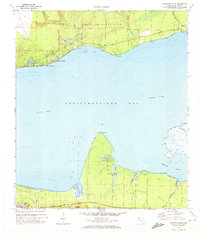
 1938 Villa Tasso1938 Print · USGSChoctawhatchee Bay and the Emerald Coast appear here in the mid-1930s, showing a landscape defined by military land and national forest. Trace early development in Valparaiso or follow the Gulf Coast Highway past coastal gems like Stewart Lake and Topsail Hill.4 unique versions available
 - 1956 Map of Villa Tasso, 1958 Print
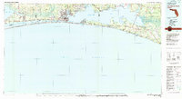
 1956 Villa Tasso1958 Print · USGSCoastal Walton and Okaloosa counties appear in the mid-fifties, showing the peninsula and bay before the rise of modern high-rise development. Genealogists and local historians can trace the early layout of Destin and find isolated landmarks like Villa Tasso, Topsail Hill, and the Destin School.2 unique versions available
 - 1957 Map of Pensacola, 1967 Print
 1957 Pensacola1967 Print · USGSThe Florida Panhandle and Alabama coast are seen here at the height of the Cold War, showcasing a unique mix of military aviation and emerging beach tourism. Genealogists and local historians can trace legacy sites like Old Corry Field, the lumber town of Bagdad, and the coastal reaches of Santa Rosa Island.3 unique versions available
 - 1959 Map of Pensacola
 1959 Pensacola1959 Print · USGSThe Florida Panhandle and Alabama coast come alive in this late fifties survey of military aviation and maritime life. Genealogists can trace family roots in Bagdad, Loxley, and Milton while mapping the rails of the Louisville and Nashville.
 - 1960 Map of Pensacola
 1960 Pensacola1960 Print · USGSThe Florida Panhandle and Alabama's eastern shore are shown during a period of rapid military and coastal growth. Genealogists and historians can trace the mid-century footprints of Warrington, the Pensacola NAS (Chevalier), and the Blackwater River timber lands.
 - 1970 Map of Choctaw Beach, 1972 Print
 1970 Choctaw Beach1972 Print · USGSChoctawhatchee Bay remains a quiet coastal frontier in the early seventies, dominated by military lands and small waterfront clusters. Researchers can map the early development of Choctaw Beach, locate the Fort Rucker Recreation Area, and trace the winding shores of Hogtown Bayou and Buck Bayou.2 unique versions available
 - 1978 Map of Fort Walton Beach, 1980 Print
 1978 Fort Walton Beach1980 Print · USGSThe Florida Panhandle in the late seventies reveals a landscape defined by the growth of Eglin Air Force Base and the shoreline of Choctawhatchee Bay. Genealogists and historians can trace the early footprints of Fort Walton Beach, Destin, and remote coastal outposts like Point Washington.2 unique versions available
 - 1994 Map of Choctaw Beach, 1999 Print
 1994 Choctaw Beach1999 Print · USGSChoctawhatchee Bay and the Walton County coastline appear here during the mid-nineties, showing the intersection of military, state, and private lands. You can trace the development of Choctaw Beach and the shores of Hogtown Bayou or find secluded spots like Fuller Lake.
End of results
Showing maps 1-9 of 9
Top cities near Sandestin
- Destin historical maps
- Niceville historical maps
- Santa Rosa Beach historical maps
- Miramar Beach historical maps
- Valparaiso historical maps
- Freeport historical maps
Frequently asked questions
- What are the different types of historical maps available for Sandestin?
- What is the oldest map of Sandestin?
- Where can I purchase historical maps of Sandestin for my home or office?
- Where can I download high-res historical maps of Sandestin?
- Are there historical topographic maps available for Sandestin?
- Is there historical aerial imagery available for Sandestin?
- Where are historical maps of Sandestin sourced from?