1940s Maps of Ebro, Florida
Explore 3 historic maps of Ebro from the 1940s. These maps offer a rare glimpse into what life looked like during the 1940s — showing old roads, neighborhoods, homes, and landmarks that have changed or disappeared over time.
Whether you're researching your family's past, planning a metal detecting trip, or studying how Ebro's landscape evolved across the 1940s, these high-resolution maps are a powerful tool for exploring the history of this region.
- Focus on a specific era: All maps on this page are from the 1940s, giving you a focused view of this time period.
- See what’s changed: Compare century-old streets, trails, and buildings to today's modern landscape using overlays and satellite layers.
- Research with precision: Use these maps for genealogy, historical research, land use analysis, or educational projects.
- View, download, or print: Maps are fully viewable online in high resolution, and can be downloaded or printed for your own records.
Start exploring Ebro's history through authentic maps from the 1940s. This is your window into the past.
Ebro, FL maps
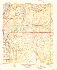
(3)- 1944 Map of Bruce, 1969 Print
 1944 Bruce1969 Print · USGSThe Choctawhatchee River bottomlands in the 1940s reveal a landscape of remote river camps and timber landings. Trace the early footprints of Bruce and Ebro, and locate riverfront sites like Cedar Tree Landing and the Ebro Sch.
 - 1945 Map of Red Head
 1945 Red Head1945 Print · USGSThe Choctawhatchee River lowlands and the southern pine forests come into focus during the mid-1940s. Genealogists and local historians can locate early community hubs like Red Head and the Oak Grove Ch, or trace landmarks like the Moody Fire Tower and Ebro Cem.4 unique versions available
 - 1945 Map of Bruce
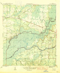 1945 Bruce1945 Print · USGSFlorida's Panhandle river country is captured here in the mid-1940s, showing the complex wetlands where Walton and Washington Counties meet. Researchers can trace the riverfront economy through sites like Cowford Ferry, Miller Landing, and the Ebro school.3 unique versions available
End of results
Showing maps 1-3 of 3
Top cities near Ebro
- Panama City historical maps
- Lynn Haven historical maps
- Panama City Beach historical maps
- DeFuniak Springs historical maps
- Freeport historical maps
- Vernon historical maps
Frequently asked questions
- What are the different types of historical maps available for Ebro?
- What is the oldest map of Ebro?
- Where can I purchase historical maps of Ebro for my home or office?
- Where can I download high-res historical maps of Ebro?
- Are there historical topographic maps available for Ebro?
- Is there historical aerial imagery available for Ebro?
- Where are historical maps of Ebro sourced from?